

7 Tage Mittelsachsen-Elbe/Elsterland-Nieder- und Oberlausitz (Juni 2018)
1. Tag: Mühlbach - Mühlberg/ Elbe
A cycling route starting in Frankenberg, Saxony, Germany.
Overview
About this route
Urlaubsstart
- -:--
- Duration
- 82.9 km
- Distance
- 127 m
- Ascent
- 366 m
- Descent
- ---
- Avg. speed
- ---
- Max. altitude

Part of
Route quality
Waytypes & surfaces along the route
Waytypes
Quiet road
36 km
(43 %)
Path
13.6 km
(16 %)
Surfaces
Paved
50.8 km
(61 %)
Unpaved
11.6 km
(14 %)
Asphalt
45.3 km
(55 %)
Ground
4.9 km
(6 %)
Continue with Bikemap
Use, edit, or download this cycling route
You would like to ride 1. Tag: Mühlbach - Mühlberg/ Elbe or customize it for your own trip? Here is what you can do with this Bikemap route:
Free features
- Save this route as favorite or in collections
- Copy & plan your own version of this route
- Split it into stages to create a multi-day tour
- Sync your route with Garmin or Wahoo
Premium features
Free trial for 3 days, or one-time payment. More about Bikemap Premium.
- Navigate this route on iOS & Android
- Export a GPX / KML file of this route
- Create your custom printout (try it for free)
- Download this route for offline navigation
Discover more Premium features.
Get Bikemap PremiumFrom our community
Other popular routes starting in Frankenberg
 Runde von Mühlbach nach Kriebstein und zurück
- Distance
- 52.8 km
- Ascent
- 698 m
- Descent
- 701 m
- Location
- Frankenberg, Saxony, Germany
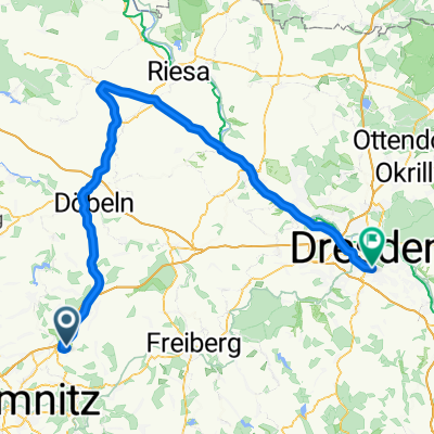 Frankenberg - Riesa - Dresden
- Distance
- 104.3 km
- Ascent
- 338 m
- Descent
- 511 m
- Location
- Frankenberg, Saxony, Germany
 6.2.2.Rundweg Lützeltal-Buchenwald-grün
- Distance
- 10.5 km
- Ascent
- 115 m
- Descent
- 114 m
- Location
- Frankenberg, Saxony, Germany
 Hainichen
- Distance
- 28.2 km
- Ascent
- 331 m
- Descent
- 334 m
- Location
- Frankenberg, Saxony, Germany
 Frankenberg - Hainichen - Oberschöna - Altenhain
- Distance
- 57 km
- Ascent
- 531 m
- Descent
- 489 m
- Location
- Frankenberg, Saxony, Germany
 Hetzdorfer Viadukt über Ranis
- Distance
- 53.6 km
- Ascent
- 728 m
- Descent
- 726 m
- Location
- Frankenberg, Saxony, Germany
 Am Mühlberg, Frankenberg/Sachsen nach Marienberger Straße, Großrückerswalde
- Distance
- 45.2 km
- Ascent
- 1,014 m
- Descent
- 688 m
- Location
- Frankenberg, Saxony, Germany
 Rund um Frankenberg 40,0km
- Distance
- 39.7 km
- Ascent
- 330 m
- Descent
- 367 m
- Location
- Frankenberg, Saxony, Germany
Open it in the app