
The Ledbury Loop
A cycling route starting in Ledbury, England, United Kingdom.
Overview
About this route
<span style="font-family: SassoonPrimaryType; font-size: medium;"><font face="SassoonPrimaryType" size="4"><span>
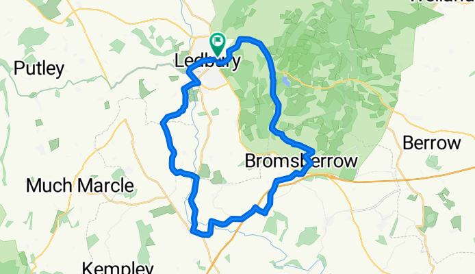
The Ledbury Loop explores the Herefordshire/Gloucestershire border; an area famous for poets and wild daffodils. This fully signed route goes
south from Ledbury to Dymock and, after crossing the ford at Clenchers
Mill, climbs steadily over hills at Eastnor. You are strongly advised to
cross the ford by the footbridge as the stream bed is notoriously slippery.
The Loop is part of the National Byway, a 3000 mile leisure cycling route
around Britain that links places of geographic, historic and cultural interest. </span></font></span>
- -:--
- Duration
- 24.7 km
- Distance
- 181 m
- Ascent
- 180 m
- Descent
- ---
- Avg. speed
- ---
- Avg. speed
Route quality
Waytypes & surfaces along the route
Waytypes
Quiet road
14.4 km
(58 %)
Busy road
4.1 km
(17 %)
Surfaces
Paved
0.7 km
(3 %)
Asphalt
0.7 km
(3 %)
Paved (undefined)
0 km
(<1 %)
Undefined
24 km
(97 %)
Continue with Bikemap
Use, edit, or download this cycling route
You would like to ride The Ledbury Loop or customize it for your own trip? Here is what you can do with this Bikemap route:
Free features
- Save this route as favorite or in collections
- Copy & plan your own version of this route
- Sync your route with Garmin or Wahoo
Premium features
Free trial for 3 days, or one-time payment. More about Bikemap Premium.
- Navigate this route on iOS & Android
- Export a GPX / KML file of this route
- Create your custom printout (try it for free)
- Download this route for offline navigation
Discover more Premium features.
Get Bikemap PremiumFrom our community
Other popular routes starting in Ledbury
 Ledbury Bosbury Balloon
- Distance
- 18.2 km
- Ascent
- 143 m
- Descent
- 143 m
- Location
- Ledbury, England, United Kingdom
 Ledbury Spiked Sausage Dog
- Distance
- 44.9 km
- Ascent
- 541 m
- Descent
- 541 m
- Location
- Ledbury, England, United Kingdom
 Ledbury Sausage Dog
- Distance
- 40.8 km
- Ascent
- 424 m
- Descent
- 424 m
- Location
- Ledbury, England, United Kingdom
 Ledbury Flint
- Distance
- 25 km
- Ascent
- 372 m
- Descent
- 373 m
- Location
- Ledbury, England, United Kingdom
 Ledbury - Staplow - Mathon - Colwall - Loop
- Distance
- 31.4 km
- Ascent
- 207 m
- Descent
- 212 m
- Location
- Ledbury, England, United Kingdom
 Ledbury VultureFish
- Distance
- 52.9 km
- Ascent
- 467 m
- Descent
- 432 m
- Location
- Ledbury, England, United Kingdom
 Liesure Ride 2010-03-13
- Distance
- 34.4 km
- Ascent
- 228 m
- Descent
- 236 m
- Location
- Ledbury, England, United Kingdom
 Ledbury - Pencombe Rtn
- Distance
- 46.5 km
- Ascent
- 398 m
- Descent
- 398 m
- Location
- Ledbury, England, United Kingdom
Open it in the app