

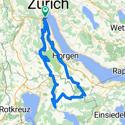
Wollishofen-Zimmerberg-Sihlbrugg-Albis-Wollishofen
A cycling route starting in Zürich (Kreis 2) / Wollishofen, Canton of Zurich, Switzerland.
Overview
About this route
Die Route führt hauptsächlich auf wenig befahrenen Nebenstrassen rund um den Sihlwald. Etwa 40 km und 700 Höhenmeter.
- -:--
- Duration
- 39.6 km
- Distance
- 771 m
- Ascent
- 755 m
- Descent
- ---
- Avg. speed
- 790 m
- Avg. speed

Route quality
Waytypes & surfaces along the route
Waytypes
Quiet road
15.7 km
(40 %)
Busy road
15.7 km
(40 %)
Surfaces
Paved
32.8 km
(83 %)
Asphalt
31.6 km
(80 %)
Paved (undefined)
1.1 km
(3 %)
Continue with Bikemap
Use, edit, or download this cycling route
You would like to ride Wollishofen-Zimmerberg-Sihlbrugg-Albis-Wollishofen or customize it for your own trip? Here is what you can do with this Bikemap route:
Free features
- Save this route as favorite or in collections
- Copy & plan your own version of this route
- Sync your route with Garmin or Wahoo
Premium features
Free trial for 3 days, or one-time payment. More about Bikemap Premium.
- Navigate this route on iOS & Android
- Export a GPX / KML file of this route
- Create your custom printout (try it for free)
- Download this route for offline navigation
Discover more Premium features.
Get Bikemap PremiumFrom our community
Other popular routes starting in Zürich (Kreis 2) / Wollishofen
 Route zu Zürich Wollishofen
- Distance
- 91.2 km
- Ascent
- 2,296 m
- Descent
- 2,295 m
- Location
- Zürich (Kreis 2) / Wollishofen, Canton of Zurich, Switzerland
 Zürich (Wollishofen)-Horgen-Menzingen-Hausen-Zürich
- Distance
- 70.3 km
- Ascent
- 1,058 m
- Descent
- 1,070 m
- Location
- Zürich (Kreis 2) / Wollishofen, Canton of Zurich, Switzerland
 Zurich 5150 1 Lap
- Distance
- 13.2 km
- Ascent
- 88 m
- Descent
- 86 m
- Location
- Zürich (Kreis 2) / Wollishofen, Canton of Zurich, Switzerland
 Zürich-Schwägalp-Appenzell
- Distance
- 102.8 km
- Ascent
- 1,154 m
- Descent
- 837 m
- Location
- Zürich (Kreis 2) / Wollishofen, Canton of Zurich, Switzerland
 Ironman Zurich Switzerland
- Distance
- 90.2 km
- Ascent
- 537 m
- Descent
- 535 m
- Location
- Zürich (Kreis 2) / Wollishofen, Canton of Zurich, Switzerland
 Zürich triatlon
- Distance
- 12.7 km
- Ascent
- 115 m
- Descent
- 115 m
- Location
- Zürich (Kreis 2) / Wollishofen, Canton of Zurich, Switzerland
 Nyugat-Alpok hágótúra
- Distance
- 1,607.4 km
- Ascent
- 16,286 m
- Descent
- 16,258 m
- Location
- Zürich (Kreis 2) / Wollishofen, Canton of Zurich, Switzerland
 Tour du Lac
- Distance
- 66.2 km
- Ascent
- 345 m
- Descent
- 344 m
- Location
- Zürich (Kreis 2) / Wollishofen, Canton of Zurich, Switzerland
Open it in the app