

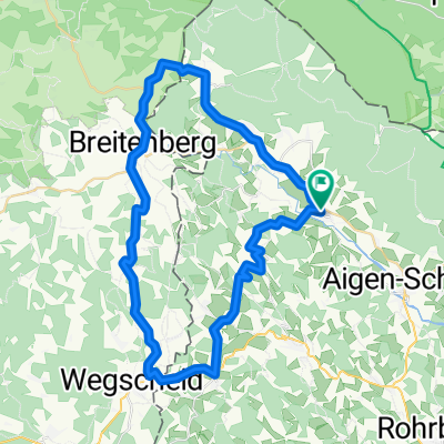
JULBACH-JULBACH
A cycling route starting in Ulrichsberg, Upper Austria, Austria.
Overview
About this route
- -:--
- Duration
- 45.9 km
- Distance
- 775 m
- Ascent
- 780 m
- Descent
- ---
- Avg. speed
- ---
- Avg. speed
Route quality
Waytypes & surfaces along the route
Waytypes
Quiet road
27.4 km
(60 %)
Road
15.9 km
(35 %)
Surfaces
Paved
10.1 km
(22 %)
Unpaved
0 km
(<1 %)
Asphalt
10.1 km
(22 %)
Ground
0 km
(<1 %)
Continue with Bikemap
Use, edit, or download this cycling route
You would like to ride JULBACH-JULBACH or customize it for your own trip? Here is what you can do with this Bikemap route:
Free features
- Save this route as favorite or in collections
- Copy & plan your own version of this route
- Sync your route with Garmin or Wahoo
Premium features
Free trial for 3 days, or one-time payment. More about Bikemap Premium.
- Navigate this route on iOS & Android
- Export a GPX / KML file of this route
- Create your custom printout (try it for free)
- Download this route for offline navigation
Discover more Premium features.
Get Bikemap PremiumFrom our community
Other popular routes starting in Ulrichsberg
 Schwarzenberg-Julbachrunde
- Distance
- 48.3 km
- Ascent
- 776 m
- Descent
- 776 m
- Location
- Ulrichsberg, Upper Austria, Austria
 Breitenberg - Cerneho jezera 105 km
- Distance
- 104.8 km
- Ascent
- 2,344 m
- Descent
- 1,991 m
- Location
- Ulrichsberg, Upper Austria, Austria
 Lusweg 5, Klaffer am Hochficht nach Lusweg 5, Klaffer am Hochficht
- Distance
- 67.8 km
- Ascent
- 920 m
- Descent
- 1,016 m
- Location
- Ulrichsberg, Upper Austria, Austria
 Home - Hochficht - Home
- Distance
- 27.3 km
- Ascent
- 808 m
- Descent
- 809 m
- Location
- Ulrichsberg, Upper Austria, Austria
 JULBACH-JULBACH
- Distance
- 45.9 km
- Ascent
- 775 m
- Descent
- 780 m
- Location
- Ulrichsberg, Upper Austria, Austria
 Schwemmkanalrunde 52km
- Distance
- 53 km
- Ascent
- 714 m
- Descent
- 715 m
- Location
- Ulrichsberg, Upper Austria, Austria
 Schöneben-Plöckensteinersee
- Distance
- 47.4 km
- Ascent
- 785 m
- Descent
- 796 m
- Location
- Ulrichsberg, Upper Austria, Austria
 Route in Ulrichsberg
- Distance
- 67.4 km
- Ascent
- 1,303 m
- Descent
- 1,304 m
- Location
- Ulrichsberg, Upper Austria, Austria
Open it in the app