
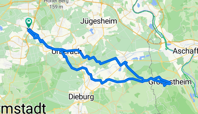
Von Hessen nach Bayern - Tour nach Großostheim
A cycling route starting in Dreieich, Hesse, Germany.
Overview
About this route
Donnerstag, 25.10.2018, 9:30 Uhr - 17:00 Uhr,
***, 75 km, 300 hm
Eine Wald und Wiesen-Tour auf neuen Radwegen, meistens auf Asphalt.
Der Hinweg führt über Ober-Roden, Babenhausen und Schafheim. Der Rückweg führt über Langstadt, Münster, Eppershausen und Urberach zurück nach Dreieich.
- -:--
- Duration
- 72 km
- Distance
- 178 m
- Ascent
- 175 m
- Descent
- ---
- Avg. speed
- ---
- Avg. speed

Route quality
Waytypes & surfaces along the route
Waytypes
Track
24.3 km
(34 %)
Quiet road
19.7 km
(27 %)
Surfaces
Paved
53.1 km
(74 %)
Unpaved
10.9 km
(15 %)
Asphalt
48.9 km
(68 %)
Gravel
7.6 km
(10 %)
Continue with Bikemap
Use, edit, or download this cycling route
You would like to ride Von Hessen nach Bayern - Tour nach Großostheim or customize it for your own trip? Here is what you can do with this Bikemap route:
Free features
- Save this route as favorite or in collections
- Copy & plan your own version of this route
- Sync your route with Garmin or Wahoo
Premium features
Free trial for 3 days, or one-time payment. More about Bikemap Premium.
- Navigate this route on iOS & Android
- Export a GPX / KML file of this route
- Create your custom printout (try it for free)
- Download this route for offline navigation
Discover more Premium features.
Get Bikemap PremiumFrom our community
Other popular routes starting in Dreieich
 Ober-Ramstädter Alpen
- Distance
- 50.3 km
- Ascent
- 297 m
- Descent
- 298 m
- Location
- Dreieich, Hesse, Germany
 80km zur Burg Frankenstein CLONED FROM ROUTE 651325
- Distance
- 84.2 km
- Ascent
- 518 m
- Descent
- 519 m
- Location
- Dreieich, Hesse, Germany
 Rodgau-Runde nach Feierabend
- Distance
- 47.8 km
- Ascent
- 240 m
- Descent
- 211 m
- Location
- Dreieich, Hesse, Germany
 Sprendlingen zum Gehspitzweiher
- Distance
- 5.6 km
- Ascent
- 25 m
- Descent
- 35 m
- Location
- Dreieich, Hesse, Germany
 Trials around Dreieich
- Distance
- 28 km
- Ascent
- 133 m
- Descent
- 112 m
- Location
- Dreieich, Hesse, Germany
 Dreieich - Rödermark - Rodgau - Dietzenbach - Dreieich
- Distance
- 36.1 km
- Ascent
- 121 m
- Descent
- 128 m
- Location
- Dreieich, Hesse, Germany
 von Sprendlingen zum Flughafen und zurück
- Distance
- 18.8 km
- Ascent
- 98 m
- Descent
- 98 m
- Location
- Dreieich, Hesse, Germany
 Sprendlingen Wildschützersteinbruch
- Distance
- 21.7 km
- Ascent
- 153 m
- Descent
- 147 m
- Location
- Dreieich, Hesse, Germany
Open it in the app