
Walhalla Donauradweg
A cycling route starting in Donaustauf, Bavaria, Germany.
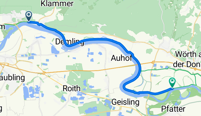
Overview
About this route
Von der Walhalla entlang der Donau.
- -:--
- Duration
- 17.6 km
- Distance
- 0 m
- Ascent
- 8 m
- Descent
- ---
- Avg. speed
- ---
- Avg. speed

Continue with Bikemap
Use, edit, or download this cycling route
You would like to ride Walhalla Donauradweg or customize it for your own trip? Here is what you can do with this Bikemap route:
Free features
- Save this route as favorite or in collections
- Copy & plan your own version of this route
- Sync your route with Garmin or Wahoo
Premium features
Free trial for 3 days, or one-time payment. More about Bikemap Premium.
- Navigate this route on iOS & Android
- Export a GPX / KML file of this route
- Create your custom printout (try it for free)
- Download this route for offline navigation
Discover more Premium features.
Get Bikemap PremiumFrom our community
Other popular routes starting in Donaustauf
 SuperTrail 1400
- Distance
- 56.7 km
- Ascent
- 772 m
- Descent
- 772 m
- Location
- Donaustauf, Bavaria, Germany
 keep_on_rolling2
- Distance
- 93.3 km
- Ascent
- 582 m
- Descent
- 546 m
- Location
- Donaustauf, Bavaria, Germany
 Tiergarten kleine Runde erweitert
- Distance
- 36.1 km
- Ascent
- 448 m
- Descent
- 446 m
- Location
- Donaustauf, Bavaria, Germany
 Radrunde von Bach an der Donau nach Wiesent
- Distance
- 13.8 km
- Ascent
- 36 m
- Descent
- 27 m
- Location
- Donaustauf, Bavaria, Germany
 IM Regensburg Hills
- Distance
- 23.4 km
- Ascent
- 389 m
- Descent
- 403 m
- Location
- Donaustauf, Bavaria, Germany
 Tegernheim Mountainbiken
- Distance
- 27.7 km
- Ascent
- 401 m
- Descent
- 401 m
- Location
- Donaustauf, Bavaria, Germany
 test
test- Distance
- 644 km
- Ascent
- 39 m
- Descent
- 84 m
- Location
- Donaustauf, Bavaria, Germany
 Einfache Fahrt in Donaustauf
- Distance
- 12.5 km
- Ascent
- 455 m
- Descent
- 252 m
- Location
- Donaustauf, Bavaria, Germany
Open it in the app