

TGC 2019, etape 1
A cycling route starting in Pont-de-Chéruy, Auvergne-Rhône-Alpes, France.
Overview
About this route
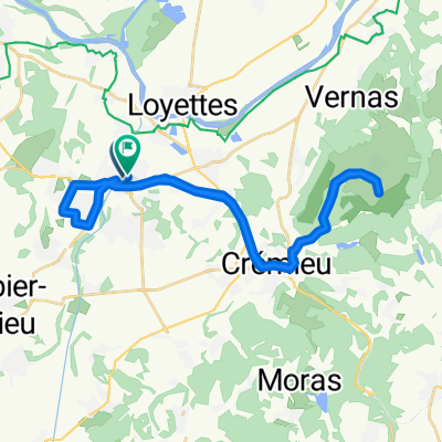
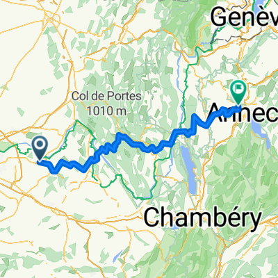
(Lyon)Pont-de-Chéruy - Annecy
- -:--
- Duration
- 131.3 km
- Distance
- 1,901 m
- Ascent
- 1,650 m
- Descent
- ---
- Avg. speed
- ---
- Avg. speed

Route quality
Waytypes & surfaces along the route
Waytypes
Road
72.6 km
(55 %)
Busy road
41.2 km
(31 %)
Surfaces
Paved
41.1 km
(31 %)
Unpaved
0.6 km
(<1 %)
Asphalt
41 km
(31 %)
Gravel
0.3 km
(<1 %)
Continue with Bikemap
Use, edit, or download this cycling route
You would like to ride TGC 2019, etape 1 or customize it for your own trip? Here is what you can do with this Bikemap route:
Free features
- Save this route as favorite or in collections
- Copy & plan your own version of this route
- Sync your route with Garmin or Wahoo
Premium features
Free trial for 3 days, or one-time payment. More about Bikemap Premium.
- Navigate this route on iOS & Android
- Export a GPX / KML file of this route
- Create your custom printout (try it for free)
- Download this route for offline navigation
Discover more Premium features.
Get Bikemap PremiumFrom our community
Other popular routes starting in Pont-de-Chéruy
 Pont-de-Chéruy Cycling
- Distance
- 36.6 km
- Ascent
- 276 m
- Descent
- 265 m
- Location
- Pont-de-Chéruy, Auvergne-Rhône-Alpes, France
 Etappe 7 Pont de Cheruy ---> Romans sur Isere 116 km
- Distance
- 115.9 km
- Ascent
- 822 m
- Descent
- 865 m
- Location
- Pont-de-Chéruy, Auvergne-Rhône-Alpes, France
 pt de cheruy-hauterives
- Distance
- 99.7 km
- Ascent
- 562 m
- Descent
- 455 m
- Location
- Pont-de-Chéruy, Auvergne-Rhône-Alpes, France
 pt de cheruy-hauterives
- Distance
- 106.5 km
- Ascent
- 547 m
- Descent
- 436 m
- Location
- Pont-de-Chéruy, Auvergne-Rhône-Alpes, France
 leg 2
leg 2- Distance
- 16.1 km
- Ascent
- 232 m
- Descent
- 180 m
- Location
- Pont-de-Chéruy, Auvergne-Rhône-Alpes, France
 TGC 2019, etape 1
- Distance
- 131.3 km
- Ascent
- 1,901 m
- Descent
- 1,650 m
- Location
- Pont-de-Chéruy, Auvergne-Rhône-Alpes, France
 Pont-de-Chéruy Cycling
- Distance
- 136 km
- Ascent
- 2,361 m
- Descent
- 2,110 m
- Location
- Pont-de-Chéruy, Auvergne-Rhône-Alpes, France
 12 Rue des Quatre Buissons, Tignieu-Jameyzieu à 4 Rue du Bochet, Tignieu-Jameyzieu
- Distance
- 0.7 km
- Ascent
- 0 m
- Descent
- 0 m
- Location
- Pont-de-Chéruy, Auvergne-Rhône-Alpes, France
Open it in the app