

Köppchensee Tegeler Flies
A cycling route starting in Stahnsdorf, Brandenburg, Germany.
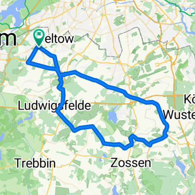
Overview
About this route
TAHUNA track
- -:--
- Duration
- 38.5 km
- Distance
- 69 m
- Ascent
- 72 m
- Descent
- ---
- Avg. speed
- ---
- Avg. speed

Route quality
Waytypes & surfaces along the route
Waytypes
Busy road
14 km
(36 %)
Path
7 km
(18 %)
Surfaces
Paved
35.1 km
(91 %)
Unpaved
0.3 km
(<1 %)
Asphalt
30.5 km
(79 %)
Paving stones
4 km
(10 %)
Continue with Bikemap
Use, edit, or download this cycling route
You would like to ride Köppchensee Tegeler Flies or customize it for your own trip? Here is what you can do with this Bikemap route:
Free features
- Save this route as favorite or in collections
- Copy & plan your own version of this route
- Sync your route with Garmin or Wahoo
Premium features
Free trial for 3 days, or one-time payment. More about Bikemap Premium.
- Navigate this route on iOS & Android
- Export a GPX / KML file of this route
- Create your custom printout (try it for free)
- Download this route for offline navigation
Discover more Premium features.
Get Bikemap PremiumFrom our community
Other popular routes starting in Stahnsdorf
 Mountainbike Runde Stahnsdorf - Teufelsberg - Stahnsdorf
- Distance
- 69.8 km
- Ascent
- 485 m
- Descent
- 467 m
- Location
- Stahnsdorf, Brandenburg, Germany
 perm Hennickendorf
- Distance
- 71.9 km
- Ascent
- 276 m
- Descent
- 272 m
- Location
- Stahnsdorf, Brandenburg, Germany
 Potsdamer alle 115
- Distance
- 4.7 km
- Ascent
- 31 m
- Descent
- 63 m
- Location
- Stahnsdorf, Brandenburg, Germany
 Mountainbike Runde Schwielowsee
- Distance
- 94.1 km
- Ascent
- 307 m
- Descent
- 309 m
- Location
- Stahnsdorf, Brandenburg, Germany
 perm KOCMO Runde
- Distance
- 81.4 km
- Ascent
- 400 m
- Descent
- 396 m
- Location
- Stahnsdorf, Brandenburg, Germany
 perm kleine Eichhörnchen
- Distance
- 44.8 km
- Ascent
- 101 m
- Descent
- 98 m
- Location
- Stahnsdorf, Brandenburg, Germany
 De L76 107, Stahnsdorf a Potsdamer Allee 113, Stahnsdorf
- Distance
- 62.6 km
- Ascent
- 278 m
- Descent
- 318 m
- Location
- Stahnsdorf, Brandenburg, Germany
 perm Fit2000-Mittenwalde
- Distance
- 71.5 km
- Ascent
- 173 m
- Descent
- 178 m
- Location
- Stahnsdorf, Brandenburg, Germany
Open it in the app