

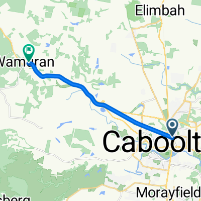
Caboolture rail trail to Wamuran Basin
A cycling route starting in Caboolture, Queensland, Australia.
Overview
About this route
- 45 min
- Duration
- 15.9 km
- Distance
- 163 m
- Ascent
- 99 m
- Descent
- 21.1 km/h
- Avg. speed
- ---
- Avg. speed
Route quality
Waytypes & surfaces along the route
Waytypes
Cycleway
8.9 km
(56 %)
Quiet road
3.2 km
(20 %)
Surfaces
Paved
14.3 km
(90 %)
Unpaved
0.5 km
(3 %)
Asphalt
10.8 km
(68 %)
Concrete
3.5 km
(22 %)
Continue with Bikemap
Use, edit, or download this cycling route
You would like to ride Caboolture rail trail to Wamuran Basin or customize it for your own trip? Here is what you can do with this Bikemap route:
Free features
- Save this route as favorite or in collections
- Copy & plan your own version of this route
- Sync your route with Garmin or Wahoo
Premium features
Free trial for 3 days, or one-time payment. More about Bikemap Premium.
- Navigate this route on iOS & Android
- Export a GPX / KML file of this route
- Create your custom printout (try it for free)
- Download this route for offline navigation
Discover more Premium features.
Get Bikemap PremiumFrom our community
Other popular routes starting in Caboolture
 Mt Mee Lookout
- Distance
- 32.1 km
- Ascent
- 580 m
- Descent
- 123 m
- Location
- Caboolture, Queensland, Australia
 Smiths Road 144, Caboolture to Woodvamp Street 6, Caboolture
- Distance
- 24.7 km
- Ascent
- 109 m
- Descent
- 110 m
- Location
- Caboolture, Queensland, Australia
 Caboolture-Moorina-Morayfield
- Distance
- 31.5 km
- Ascent
- 190 m
- Descent
- 191 m
- Location
- Caboolture, Queensland, Australia
 Caboolture to Wamuran rail trail
- Distance
- 10.2 km
- Ascent
- 80 m
- Descent
- 39 m
- Location
- Caboolture, Queensland, Australia
 Flinders Tour 2012
- Distance
- 24 km
- Ascent
- 263 m
- Descent
- 262 m
- Location
- Caboolture, Queensland, Australia
 Wildhorse Mountain Lookout
- Distance
- 26.2 km
- Ascent
- 25 m
- Descent
- 63 m
- Location
- Caboolture, Queensland, Australia
 Caboolture, Elimbah, Wamuran return
- Distance
- 34.5 km
- Ascent
- 196 m
- Descent
- 198 m
- Location
- Caboolture, Queensland, Australia
 State Route 60 46, Caboolture to Beerburrum Road 42, Caboolture
- Distance
- 44.7 km
- Ascent
- 595 m
- Descent
- 593 m
- Location
- Caboolture, Queensland, Australia
Open it in the app