

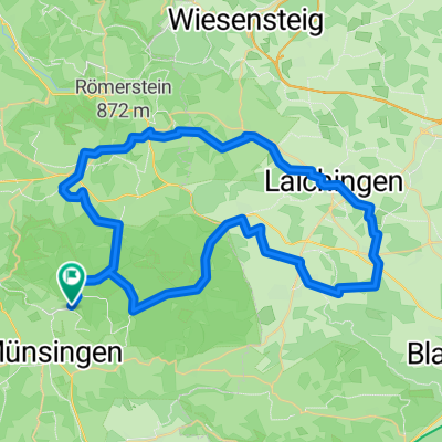
Muensingen - Feldstetten
A cycling route starting in Münsingen, Baden-Württemberg, Germany.
Overview
About this route
Autofrei ueber den ehemaligen Truppenuebungsplatz durchs Biosphaerengebiet. Kuppenalb, alte Alleebaeume. 7m breite Betonpiste. So weit weg von allen Strassen, dass wirklich Stille herrscht. Dies ist die direkte Verbindung, die in der ADFC-Radtourenkarte 25 nicht mitaufgenommen wurde (obwohl die Oeffnung des TrUebPl. damals schon feststand). Vergiss den dort eingetragenen anstrengenden Umweg ueber Boettingen, Magolsheim, Herolstadt.
- -:--
- Duration
- 14.8 km
- Distance
- 178 m
- Ascent
- 117 m
- Descent
- ---
- Avg. speed
- 801 m
- Avg. speed

Route quality
Waytypes & surfaces along the route
Waytypes
Quiet road
12.1 km
(82 %)
Track
1.1 km
(7 %)
Surfaces
Paved
11 km
(74 %)
Asphalt
10.9 km
(74 %)
Paved (undefined)
0.1 km
(<1 %)
Undefined
3.8 km
(26 %)
Route highlights
Points of interest along the route
Point of interest after 3.3 km
Windraeder
Point of interest after 4.8 km
Eingang Biosphaerenreservat - ab hier autofrei.
Point of interest after 7.6 km
Passhoehe 801 m
Point of interest after 8.1 km
Turm Seeckt
Point of interest after 11.9 km
Passhoehe 801 m
Continue with Bikemap
Use, edit, or download this cycling route
You would like to ride Muensingen - Feldstetten or customize it for your own trip? Here is what you can do with this Bikemap route:
Free features
- Save this route as favorite or in collections
- Copy & plan your own version of this route
- Sync your route with Garmin or Wahoo
Premium features
Free trial for 3 days, or one-time payment. More about Bikemap Premium.
- Navigate this route on iOS & Android
- Export a GPX / KML file of this route
- Create your custom printout (try it for free)
- Download this route for offline navigation
Discover more Premium features.
Get Bikemap PremiumFrom our community
Other popular routes starting in Münsingen
 Buchbare Tour 4 | 4. Tag Variante 1
- Distance
- 8 km
- Ascent
- 145 m
- Descent
- 141 m
- Location
- Münsingen, Baden-Württemberg, Germany
 MÜNSINGER E-BIKE TOUR 1: Gestütshof und Rutschenfelsen
- Distance
- 45.2 km
- Ascent
- 657 m
- Descent
- 660 m
- Location
- Münsingen, Baden-Württemberg, Germany
 Buchbare Tour 4 | 3. Tag
- Distance
- 18.1 km
- Ascent
- 334 m
- Descent
- 333 m
- Location
- Münsingen, Baden-Württemberg, Germany
 Alb Gold Tour
- Distance
- 67 km
- Ascent
- 627 m
- Descent
- 626 m
- Location
- Münsingen, Baden-Württemberg, Germany
 Über die Albhöhen ins Lautertal
- Distance
- 38.4 km
- Ascent
- 665 m
- Descent
- 680 m
- Location
- Münsingen, Baden-Württemberg, Germany
 Buchbare Tour 4 | 2. Tag
- Distance
- 10.8 km
- Ascent
- 196 m
- Descent
- 195 m
- Location
- Münsingen, Baden-Württemberg, Germany
 Trailfinger Säge-Laichingen
- Distance
- 59.4 km
- Ascent
- 857 m
- Descent
- 856 m
- Location
- Münsingen, Baden-Württemberg, Germany
 Alb Gold Trophy 2007
- Distance
- 80 km
- Ascent
- 837 m
- Descent
- 837 m
- Location
- Münsingen, Baden-Württemberg, Germany
Open it in the app