

MBG - Sat 19 Jan 2019 1/2 Island Ride
A cycling route starting in Singapore, Central Singapore Community Development Council, Singapore.
Overview
About this route
Meeting Point: Legend @ Anchorvale Community Club
Moving out time: 0730 hrs sharp
End time : 1230 hrs
Breakfast Point : Maxwell Market
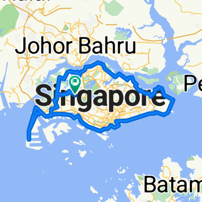
Route : (subject to changes when necessary)
AVCC - Fernvale St - Fernvale Rd - Sengkang West Way - Sengkang West Rd - KnightsbridgeRd - Seletar Aerospace Dr - West Camp Rd - Yishun Ave 1 - Sembawang Rd - Upper Thomson Rd - Marymount Lane - Marymount Rd - Thomson Rd - Kampong Java Rd - Bukit Timah Rd - Sungei Rd - Ophir Rd - North Bridge Rd - South Bridge Rd - Erskine Rd - Maxwell Market (breakfast stop)
Maxwell Rd - Cecil St - Collyer Quay - Esplanade Dr - Nicoll Highway - Stadium Dr - Stadium Walk - Stadium Cres - Stadium Way - Tanjong Rhu Bridge - Tanjong Rhu Rd - ECP Service Rd (1st re-group @ ECP B1 carpark)
East Coast Service Rd - East Coast PCN (2nd regroup @NSRCC)
Tanah Merah Coast Rd - Nicoll Dr - Telok Paku Rd - Netheravon Rd - Cranwell Rd - Loyang Ave (4th regroup @ Shell station)
Pasir Ris Dr 3 - Pasir Ris Dr 12 - Pasir Ris Ind Dr 1 - Pasir Ris Farmway - EC Club Cafe @ Oasis Terrace
- -:--
- Duration
- 84 km
- Distance
- 214 m
- Ascent
- 206 m
- Descent
- ---
- Avg. speed
- ---
- Avg. speed
Continue with Bikemap
Use, edit, or download this cycling route
You would like to ride MBG - Sat 19 Jan 2019 1/2 Island Ride or customize it for your own trip? Here is what you can do with this Bikemap route:
Free features
- Save this route as favorite or in collections
- Copy & plan your own version of this route
- Sync your route with Garmin or Wahoo
Premium features
Free trial for 3 days, or one-time payment. More about Bikemap Premium.
- Navigate this route on iOS & Android
- Export a GPX / KML file of this route
- Create your custom printout (try it for free)
- Download this route for offline navigation
Discover more Premium features.
Get Bikemap PremiumFrom our community
Other popular routes starting in Singapore
 First Round Island for 2021
- Distance
- 122.5 km
- Ascent
- 1,707 m
- Descent
- 1,705 m
- Location
- Singapore, Central Singapore Community Development Council, Singapore
 170C Punggol Field, Punggol to Punggol East, Punggol
- Distance
- 86 km
- Ascent
- 10 m
- Descent
- 30 m
- Location
- Singapore, Central Singapore Community Development Council, Singapore
 Give it a hundred %
- Distance
- 99.7 km
- Ascent
- 95 m
- Descent
- 87 m
- Location
- Singapore, Central Singapore Community Development Council, Singapore
 NorthernScenicExplorer
- Distance
- 38.8 km
- Ascent
- 177 m
- Descent
- 177 m
- Location
- Singapore, Central Singapore Community Development Council, Singapore
 RTI Shore Loop
- Distance
- 132 km
- Ascent
- 635 m
- Descent
- 642 m
- Location
- Singapore, Central Singapore Community Development Council, Singapore
 Tampines Simei Loop
- Distance
- 14.2 km
- Ascent
- 94 m
- Descent
- 91 m
- Location
- Singapore, Central Singapore Community Development Council, Singapore
 Tampines To Hyderabad/Kay Siang/Ridley Park
- Distance
- 58.1 km
- Ascent
- 477 m
- Descent
- 477 m
- Location
- Singapore, Central Singapore Community Development Council, Singapore
 RTI CHILL RIDE
- Distance
- 173.2 km
- Ascent
- 191 m
- Descent
- 197 m
- Location
- Singapore, Central Singapore Community Development Council, Singapore
Open it in the app