

Schrobenhausen-Walda
A cycling route starting in Schrobenhausen, Bavaria, Germany.
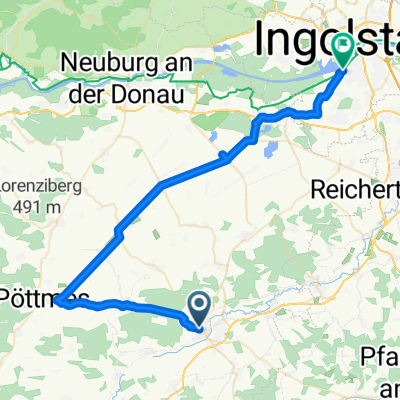
Overview
About this route
Bahnhofstraße 32, 86529 Schrobenhausen
Landgasthof Walda, Wald
Ruhetage: Montag + Dienstag 11 - 13 Uhr
- 4 h 5 min
- Duration
- 65.4 km
- Distance
- 292 m
- Ascent
- 294 m
- Descent
- 16 km/h
- Avg. speed
- 469 m
- Avg. speed

Route quality
Waytypes & surfaces along the route
Waytypes
Path
30 km
(46 %)
Quiet road
18.3 km
(28 %)
Surfaces
Paved
52.6 km
(80 %)
Unpaved
3.6 km
(6 %)
Asphalt
47.9 km
(73 %)
Paved (undefined)
4.7 km
(7 %)
Route highlights
Points of interest along the route
Accommodation after 38.8 km
Gasthaus Daferner
Continue with Bikemap
Use, edit, or download this cycling route
You would like to ride Schrobenhausen-Walda or customize it for your own trip? Here is what you can do with this Bikemap route:
Free features
- Save this route as favorite or in collections
- Copy & plan your own version of this route
- Sync your route with Garmin or Wahoo
Premium features
Free trial for 3 days, or one-time payment. More about Bikemap Premium.
- Navigate this route on iOS & Android
- Export a GPX / KML file of this route
- Create your custom printout (try it for free)
- Download this route for offline navigation
Discover more Premium features.
Get Bikemap PremiumFrom our community
Other popular routes starting in Schrobenhausen
 SOB Hörzhausen Goachat
- Distance
- 14 km
- Ascent
- 92 m
- Descent
- 91 m
- Location
- Schrobenhausen, Bavaria, Germany
 021 SOB-Ingstetten-Pöttmes-SOB
- Distance
- 49.8 km
- Ascent
- 223 m
- Descent
- 221 m
- Location
- Schrobenhausen, Bavaria, Germany
 Schrobenhausen_Ingolstadt
- Distance
- 46.9 km
- Ascent
- 40 m
- Descent
- 81 m
- Location
- Schrobenhausen, Bavaria, Germany
 009 Altomünster-Gerolsbach-Hohenwart-Hohenried
- Distance
- 77.8 km
- Ascent
- 667 m
- Descent
- 690 m
- Location
- Schrobenhausen, Bavaria, Germany
 Mariabrunn
- Distance
- 85.2 km
- Ascent
- 794 m
- Descent
- 787 m
- Location
- Schrobenhausen, Bavaria, Germany
 018 SOB-Wolfsberg-Gerolsbach-SOB
- Distance
- 56.2 km
- Ascent
- 341 m
- Descent
- 341 m
- Location
- Schrobenhausen, Bavaria, Germany
 Birkenheide 2
- Distance
- 92.6 km
- Ascent
- 227 m
- Descent
- 226 m
- Location
- Schrobenhausen, Bavaria, Germany
 BR Radltour 2013 - Etappe 2 - Schrobenhausen - Manching- Münchsmünster - Kelheim
- Distance
- 80.6 km
- Ascent
- 109 m
- Descent
- 178 m
- Location
- Schrobenhausen, Bavaria, Germany
Open it in the app