

Trip Svit-Bratislava 3
A cycling route starting in Svit, Prešovský kraj, Slovak Republic.
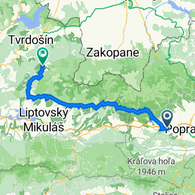
Overview
About this route
- -:--
- Duration
- 388.1 km
- Distance
- 1,711 m
- Ascent
- 2,290 m
- Descent
- ---
- Avg. speed
- ---
- Avg. speed

Route quality
Waytypes & surfaces along the route
Waytypes
Road
128.8 km
(33 %)
Track
90.1 km
(23 %)
Surfaces
Paved
188.4 km
(49 %)
Unpaved
74.6 km
(19 %)
Asphalt
169.6 km
(44 %)
Gravel
44.9 km
(12 %)
Route highlights
Points of interest along the route
Point of interest after 60.5 km
kemp https://goo.gl/maps/pHKf7tFFuy62
Point of interest after 66.2 km
Vstup bez platenia na kempovú pláž
Point of interest after 67 km
kemp L mara
Point of interest after 154.4 km
možnosť ubytovania https://www.megaubytovanie.sk/chatka-cremosne
Point of interest after 240 km
kemp https://goo.gl/maps/YygUAPHv8jB2
Point of interest after 240.7 km
Horná dolná 25km
Continue with Bikemap
Use, edit, or download this cycling route
You would like to ride Trip Svit-Bratislava 3 or customize it for your own trip? Here is what you can do with this Bikemap route:
Free features
- Save this route as favorite or in collections
- Copy & plan your own version of this route
- Sync your route with Garmin or Wahoo
Premium features
Free trial for 3 days, or one-time payment. More about Bikemap Premium.
- Navigate this route on iOS & Android
- Export a GPX / KML file of this route
- Create your custom printout (try it for free)
- Download this route for offline navigation
Discover more Premium features.
Get Bikemap PremiumFrom our community
Other popular routes starting in Svit
 Teplicky Trailik
- Distance
- 1.9 km
- Ascent
- 138 m
- Descent
- 30 m
- Location
- Svit, Prešovský kraj, Slovak Republic
 Lopusna - Vrbov-Kezmarok
- Distance
- 37.1 km
- Ascent
- 175 m
- Descent
- 348 m
- Location
- Svit, Prešovský kraj, Slovak Republic
 Svit - Hágy - Popradské pleso - Lučivná - Svit
- Distance
- 45.6 km
- Ascent
- 1,099 m
- Descent
- 1,096 m
- Location
- Svit, Prešovský kraj, Slovak Republic
 Svit-Tomášovský výhlad-Podlesok-Svit
- Distance
- 69.1 km
- Ascent
- 1,567 m
- Descent
- 1,542 m
- Location
- Svit, Prešovský kraj, Slovak Republic
 Lopusna dolina - Panska Hola
- Distance
- 47.9 km
- Ascent
- 0 m
- Descent
- 0 m
- Location
- Svit, Prešovský kraj, Slovak Republic
 EBT 2023 1.etapa
- Distance
- 82.1 km
- Ascent
- 1,895 m
- Descent
- 1,850 m
- Location
- Svit, Prešovský kraj, Slovak Republic
 Vylet s láskou
- Distance
- 61.2 km
- Ascent
- 1,046 m
- Descent
- 1,073 m
- Location
- Svit, Prešovský kraj, Slovak Republic
 Svit - Kolesárky - Vikartovský mlyn
- Distance
- 23.3 km
- Ascent
- 430 m
- Descent
- 272 m
- Location
- Svit, Prešovský kraj, Slovak Republic