
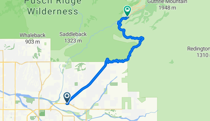
Mt. Lemmon, Mile Marker 10
A cycling route starting in Tanque Verde, Arizona, United States of America.
Overview
About this route
Cataline Highway to Mt Lemmon, mile marker 10.
- -:--
- Duration
- 23.6 km
- Distance
- 1,048 m
- Ascent
- 425 m
- Descent
- ---
- Avg. speed
- 1,403 m
- Avg. speed

Route quality
Waytypes & surfaces along the route
Waytypes
Busy road
19.8 km
(84 %)
Path
1.5 km
(6 %)
Surfaces
Unpaved
1.5 km
(6 %)
Ground
1.5 km
(6 %)
Undefined
22.1 km
(94 %)
Continue with Bikemap
Use, edit, or download this cycling route
You would like to ride Mt. Lemmon, Mile Marker 10 or customize it for your own trip? Here is what you can do with this Bikemap route:
Free features
- Save this route as favorite or in collections
- Copy & plan your own version of this route
- Sync your route with Garmin or Wahoo
Premium features
Free trial for 3 days, or one-time payment. More about Bikemap Premium.
- Navigate this route on iOS & Android
- Export a GPX / KML file of this route
- Create your custom printout (try it for free)
- Download this route for offline navigation
Discover more Premium features.
Get Bikemap PremiumFrom our community
Other popular routes starting in Tanque Verde
 Tucson , Mount Lemmon from The Buzz
- Distance
- 93.2 km
- Ascent
- 1,918 m
- Descent
- 1,918 m
- Location
- Tanque Verde, Arizona, United States of America
 Mount Lemmon
- Distance
- 80.7 km
- Ascent
- 1,878 m
- Descent
- 1,887 m
- Location
- Tanque Verde, Arizona, United States of America
 Saguaro Park East - jour 6
- Distance
- 64.8 km
- Ascent
- 473 m
- Descent
- 471 m
- Location
- Tanque Verde, Arizona, United States of America
 Quick bike tour through Tucson
- Distance
- 9.3 km
- Ascent
- ---
- Descent
- ---
- Location
- Tanque Verde, Arizona, United States of America
 3135–3199 N Amethyst Ln, Tucson to 12040 E Fort Lowell Rd, Tucson
- Distance
- 16.8 km
- Ascent
- 104 m
- Descent
- 104 m
- Location
- Tanque Verde, Arizona, United States of America
 Saguaro National Park East
- Distance
- 13.1 km
- Ascent
- 172 m
- Descent
- 163 m
- Location
- Tanque Verde, Arizona, United States of America
 3135–3199 N Amethyst Ln, Tucson to 3135–3199 N Amethyst Ln, Tucson
- Distance
- 16.7 km
- Ascent
- 107 m
- Descent
- 112 m
- Location
- Tanque Verde, Arizona, United States of America
 Cracking ride in Tucson
- Distance
- 32.5 km
- Ascent
- 476 m
- Descent
- 480 m
- Location
- Tanque Verde, Arizona, United States of America
Open it in the app