

Tour at Forcella Lerosa
A cycling route starting in Cortina d'Ampezzo, Veneto, Italy.
Overview
About this route
Description from ”Mountain biking in the Dolomites” book (Mauro Tumler):
For those intending to spend a longer holiday in the Dolomites, this tour is an ideal cycling introduction to the area. Most of the tour runs on the meticulously sign-posted Cortina–Dobbiaco cycle route, while the steep climb on technical terrain to the Forcella Lerosa requires a good amount of stamina. Reward is a nice single-track section with tight switchbacks from the Forcella to the Malga Ra Stua.
DIRECTIONS
Just the landscape is reason enough to get out on a bike. even the physical effort is contained with an 810 metres climb. this tour derives its name from the Forcella Lerosa, located on a high altitude alp at the beginning of the Val de Gotres. A little wooden cross commemorates an Austrian military cemetery from the Big War. the Forcella Lerosa is a popular passage for cyclists to get to Marebbe in Alto Adige, riding through the Val Salata and the Rifugio Sennes.
Itinerary description
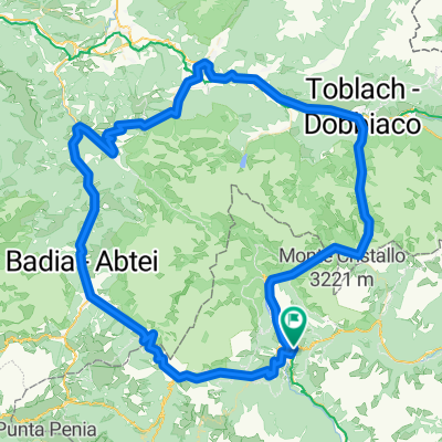
From ➊ cortina bus station (1220 m) take the sign-posted bicycle path in the direction of Dobbiaco; 1 km before the Passo di cima Banche cross the ➋ SS 51 and follow directions to Val di Gotres, and then take MtB route n. 10 to the ➌ Forcella Lerosa (2020 m). continue to ➍ Monte de Lerosa (1995 m) and from here to the left start descending on switchbacks ➎ to the Malga Ra Stua (1668 m, food available). continue on paved road to arrive at the ➏ S. Uberto car park (1449 m), and then on ➐ the village of Felizòn (1005 m), eventually riding past the ➑ Fiàmes hotel. At the camping olympia get back onto the road, cross it, and return to the starting point along the bicycle path.
Sign-posted MtB route N. 10
STARTING POINT
Cortina, 1220 m
TARGET POINT
Cortina, 1220 m
- -:--
- Duration
- 31.8 km
- Distance
- 821 m
- Ascent
- 822 m
- Descent
- ---
- Avg. speed
- ---
- Avg. speed

Route quality
Waytypes & surfaces along the route
Waytypes
Cycleway
15.3 km
(48 %)
Track
7.8 km
(24 %)
Surfaces
Paved
11.5 km
(36 %)
Unpaved
19.7 km
(62 %)
Gravel
15.4 km
(49 %)
Asphalt
11.2 km
(35 %)
Continue with Bikemap
Use, edit, or download this cycling route
You would like to ride Tour at Forcella Lerosa or customize it for your own trip? Here is what you can do with this Bikemap route:
Free features
- Save this route as favorite or in collections
- Copy & plan your own version of this route
- Sync your route with Garmin or Wahoo
Premium features
Free trial for 3 days, or one-time payment. More about Bikemap Premium.
- Navigate this route on iOS & Android
- Export a GPX / KML file of this route
- Create your custom printout (try it for free)
- Download this route for offline navigation
Discover more Premium features.
Get Bikemap PremiumFrom our community
Other popular routes starting in Cortina d'Ampezzo
 Cortina d`Ampezzo - Toblach MTB Marathon
- Distance
- 43.5 km
- Ascent
- 573 m
- Descent
- 575 m
- Location
- Cortina d'Ampezzo, Veneto, Italy
 Via Guglielmo Marconi, Cortina d'Ampezzo to SS 13, Chiusaforte
- Distance
- 149.7 km
- Ascent
- 4,574 m
- Descent
- 5,412 m
- Location
- Cortina d'Ampezzo, Veneto, Italy
 Olympia camp - Cinque torri - P. So. giau. Olympia camp
- Distance
- 44.1 km
- Ascent
- 1,715 m
- Descent
- 1,715 m
- Location
- Cortina d'Ampezzo, Veneto, Italy
 Cortina … San Candido
- Distance
- 76 km
- Ascent
- 1,018 m
- Descent
- 1,014 m
- Location
- Cortina d'Ampezzo, Veneto, Italy
 Cortina P. Furcia, Cimabanche
- Distance
- 121.2 km
- Ascent
- 2,206 m
- Descent
- 2,203 m
- Location
- Cortina d'Ampezzo, Veneto, Italy
 Dol 3 Zinnen
- Distance
- 16.1 km
- Ascent
- 738 m
- Descent
- 739 m
- Location
- Cortina d'Ampezzo, Veneto, Italy
 5 Rifugi
- Distance
- 31.6 km
- Ascent
- 1,404 m
- Descent
- 1,404 m
- Location
- Cortina d'Ampezzo, Veneto, Italy
 cortina giro dei sette rifugi
- Distance
- 57.2 km
- Ascent
- 1,917 m
- Descent
- 1,917 m
- Location
- Cortina d'Ampezzo, Veneto, Italy
Open it in the app