
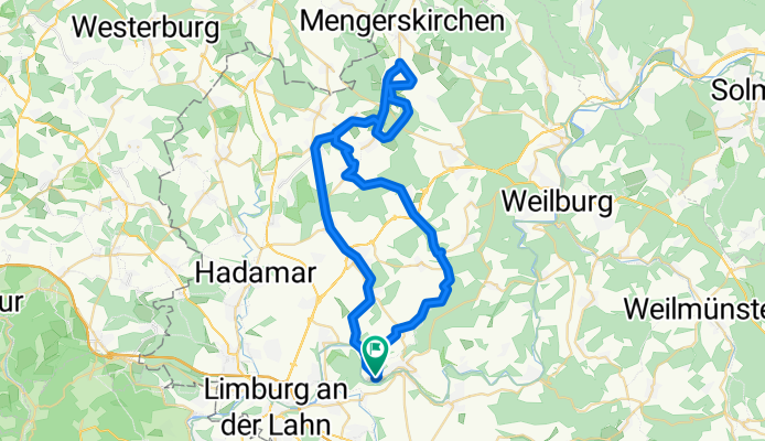
Kerkerbachtal-Radweg
A cycling route starting in Runkel, Hesse, Germany.
Overview
About this route
- -:--
- Duration
- 53.5 km
- Distance
- 442 m
- Ascent
- 440 m
- Descent
- ---
- Avg. speed
- ---
- Avg. speed

Route quality
Waytypes & surfaces along the route
Waytypes
Track
21.9 km
(41 %)
Road
12.2 km
(23 %)
Surfaces
Paved
22.6 km
(42 %)
Unpaved
8.1 km
(15 %)
Asphalt
12.4 km
(23 %)
Paved (undefined)
10.2 km
(19 %)
Continue with Bikemap
Use, edit, or download this cycling route
You would like to ride Kerkerbachtal-Radweg or customize it for your own trip? Here is what you can do with this Bikemap route:
Free features
- Save this route as favorite or in collections
- Copy & plan your own version of this route
- Sync your route with Garmin or Wahoo
Premium features
Free trial for 3 days, or one-time payment. More about Bikemap Premium.
- Navigate this route on iOS & Android
- Export a GPX / KML file of this route
- Create your custom printout (try it for free)
- Download this route for offline navigation
Discover more Premium features.
Get Bikemap PremiumFrom our community
Other popular routes starting in Runkel
 Drei-Seen-Tour Westerwald
- Distance
- 100.1 km
- Ascent
- 766 m
- Descent
- 766 m
- Location
- Runkel, Hesse, Germany
 RTF Brechen
- Distance
- 101.9 km
- Ascent
- 1,185 m
- Descent
- 1,158 m
- Location
- Runkel, Hesse, Germany
 Schadeck-Königstein (Opel Zoo)
- Distance
- 42.9 km
- Ascent
- 584 m
- Descent
- 428 m
- Location
- Runkel, Hesse, Germany
 Eschhofen-Runkel-Eschenau-Weilburg-Villmar-Eschhofen
- Distance
- 58.4 km
- Ascent
- 667 m
- Descent
- 699 m
- Location
- Runkel, Hesse, Germany
 Lahnradweg Runkel - Bad Ems
- Distance
- 61.1 km
- Ascent
- 470 m
- Descent
- 514 m
- Location
- Runkel, Hesse, Germany
 Schadeck-Eschenau-Schadeck
- Distance
- 15.4 km
- Ascent
- 259 m
- Descent
- 262 m
- Location
- Runkel, Hesse, Germany
 Ldhs-Mensf-Flacht-Linter
- Distance
- 18.9 km
- Ascent
- 206 m
- Descent
- 203 m
- Location
- Runkel, Hesse, Germany
 LHH - Weiltal - Feldberg - LHH
- Distance
- 125.3 km
- Ascent
- 786 m
- Descent
- 786 m
- Location
- Runkel, Hesse, Germany
Open it in the app