

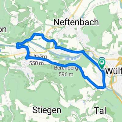
Waldtour auf und ab
A cycling route starting in Wülflingen (Kreis 6) / Härti, Canton of Zurich, Switzerland.
Overview
About this route
- -:--
- Duration
- 40.9 km
- Distance
- 681 m
- Ascent
- 682 m
- Descent
- ---
- Avg. speed
- ---
- Avg. speed
Route quality
Waytypes & surfaces along the route
Waytypes
Track
35.6 km
(87 %)
Quiet road
1.9 km
(5 %)
Surfaces
Paved
4 km
(10 %)
Unpaved
34.4 km
(84 %)
Unpaved (undefined)
16.6 km
(41 %)
Gravel
15.7 km
(38 %)
Continue with Bikemap
Use, edit, or download this cycling route
You would like to ride Waldtour auf und ab or customize it for your own trip? Here is what you can do with this Bikemap route:
Free features
- Save this route as favorite or in collections
- Copy & plan your own version of this route
- Sync your route with Garmin or Wahoo
Premium features
Free trial for 3 days, or one-time payment. More about Bikemap Premium.
- Navigate this route on iOS & Android
- Export a GPX / KML file of this route
- Create your custom printout (try it for free)
- Download this route for offline navigation
Discover more Premium features.
Get Bikemap PremiumFrom our community
Other popular routes starting in Wülflingen (Kreis 6) / Härti
 Waldtour auf und ab
- Distance
- 40.9 km
- Ascent
- 681 m
- Descent
- 682 m
- Location
- Wülflingen (Kreis 6) / Härti, Canton of Zurich, Switzerland
 Haltenrebenstrasse 59A, Winterthur nach Dorfstraße 22, Lottstetten
- Distance
- 18.9 km
- Ascent
- 244 m
- Descent
- 247 m
- Location
- Wülflingen (Kreis 6) / Härti, Canton of Zurich, Switzerland
 Neftenbach_Turbenthal_Männedorf
- Distance
- 50.2 km
- Ascent
- 552 m
- Descent
- 550 m
- Location
- Wülflingen (Kreis 6) / Härti, Canton of Zurich, Switzerland
 De Wässerwiesenstrasse 65, Winterthur a Wyden 2.1, Ossingen
- Distance
- 15.9 km
- Ascent
- 171 m
- Descent
- 175 m
- Location
- Wülflingen (Kreis 6) / Härti, Canton of Zurich, Switzerland
 Hardgutstrasse, Winterthur nach Hardgutstrasse, Winterthur
- Distance
- 9.8 km
- Ascent
- 96 m
- Descent
- 98 m
- Location
- Wülflingen (Kreis 6) / Härti, Canton of Zurich, Switzerland
 Grosse Randenrunde
- Distance
- 100.1 km
- Ascent
- 881 m
- Descent
- 881 m
- Location
- Wülflingen (Kreis 6) / Härti, Canton of Zurich, Switzerland
 Hardgutstrasse 48C, Winterthur nach J.-C.-Heer-Strasse 10.1, Winterthur
- Distance
- 55.7 km
- Ascent
- 454 m
- Descent
- 431 m
- Location
- Wülflingen (Kreis 6) / Härti, Canton of Zurich, Switzerland
 Wnterthur - Sternenberg - Winterthur
- Distance
- 75.3 km
- Ascent
- 927 m
- Descent
- 916 m
- Location
- Wülflingen (Kreis 6) / Härti, Canton of Zurich, Switzerland
Open it in the app