

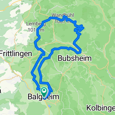
Feierabend-Rundkurs
A cycling route starting in Balgheim, Baden-Württemberg, Germany.
Overview
About this route
Balgheim über Rietheim, Wurmlingen, Esslingen, Talheim, Tuningen, Weigheim, Trossingen, Aldingen und Spaichingen wieder zurück nach Balgheim
- -:--
- Duration
- 51.4 km
- Distance
- 413 m
- Ascent
- 431 m
- Descent
- ---
- Avg. speed
- 780 m
- Avg. speed

Route quality
Waytypes & surfaces along the route
Waytypes
Road
18.7 km
(36 %)
Busy road
11.8 km
(23 %)
Surfaces
Paved
48.9 km
(95 %)
Asphalt
47.7 km
(93 %)
Paved (undefined)
1.3 km
(2 %)
Undefined
2.5 km
(5 %)
Continue with Bikemap
Use, edit, or download this cycling route
You would like to ride Feierabend-Rundkurs or customize it for your own trip? Here is what you can do with this Bikemap route:
Free features
- Save this route as favorite or in collections
- Copy & plan your own version of this route
- Sync your route with Garmin or Wahoo
Premium features
Free trial for 3 days, or one-time payment. More about Bikemap Premium.
- Navigate this route on iOS & Android
- Export a GPX / KML file of this route
- Create your custom printout (try it for free)
- Download this route for offline navigation
Discover more Premium features.
Get Bikemap PremiumFrom our community
Other popular routes starting in Balgheim
 Feierabend-Rundkurs
- Distance
- 51.4 km
- Ascent
- 413 m
- Descent
- 431 m
- Location
- Balgheim, Baden-Württemberg, Germany
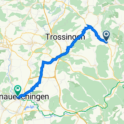
 Balgheim nach Bodman-Ludwigshafen
- Distance
- 46.8 km
- Ascent
- 566 m
- Descent
- 860 m
- Location
- Balgheim, Baden-Württemberg, Germany
 Rundkurs nach Niedereschach 55 km
- Distance
- 55.2 km
- Ascent
- 705 m
- Descent
- 705 m
- Location
- Balgheim, Baden-Württemberg, Germany
 MB-Tour Heuberg-Tanneck
- Distance
- 50.6 km
- Ascent
- 1,275 m
- Descent
- 1,279 m
- Location
- Balgheim, Baden-Württemberg, Germany
 Unnamed Road, Balgheim nach Unnamed Road, Balgheim
- Distance
- 9.8 km
- Ascent
- 306 m
- Descent
- 308 m
- Location
- Balgheim, Baden-Württemberg, Germany
 Spaichinger Straße 1/1, Balgheim nach Neue-Wolterdinger-Straße 40, Donaueschingen
- Distance
- 33.9 km
- Ascent
- 245 m
- Descent
- 245 m
- Location
- Balgheim, Baden-Württemberg, Germany
 Lange Ausfahrt durch Balgheim
- Distance
- 77.7 km
- Ascent
- 458 m
- Descent
- 458 m
- Location
- Balgheim, Baden-Württemberg, Germany
 Talheim-Esslingen-Kohlhalde
- Distance
- 40.2 km
- Ascent
- 677 m
- Descent
- 671 m
- Location
- Balgheim, Baden-Württemberg, Germany
Open it in the app