

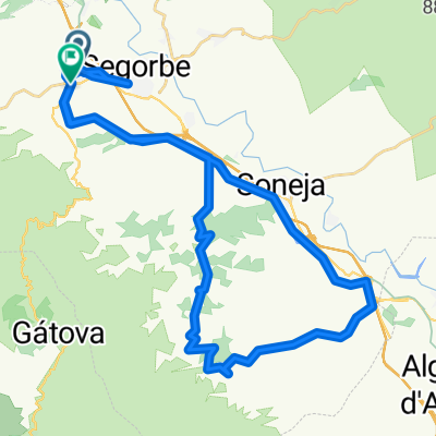
Altura - Fuentes Ayodar
A cycling route starting in Altura, Valencia, Spain.
Overview
About this route
Se puede recortar en Torralba y quedaría en 43Kms y menos de 1000 de desnivel
- -:--
- Duration
- 56.9 km
- Distance
- 998 m
- Ascent
- 870 m
- Descent
- ---
- Avg. speed
- ---
- Avg. speed
Route quality
Waytypes & surfaces along the route
Waytypes
Road
18.6 km
(33 %)
Busy road
18.6 km
(33 %)
Surfaces
Paved
10.8 km
(19 %)
Unpaved
7.1 km
(13 %)
Asphalt
10.7 km
(19 %)
Gravel
6.4 km
(11 %)
Continue with Bikemap
Use, edit, or download this cycling route
You would like to ride Altura - Fuentes Ayodar or customize it for your own trip? Here is what you can do with this Bikemap route:
Free features
- Save this route as favorite or in collections
- Copy & plan your own version of this route
- Sync your route with Garmin or Wahoo
Premium features
Free trial for 3 days, or one-time payment. More about Bikemap Premium.
- Navigate this route on iOS & Android
- Export a GPX / KML file of this route
- Create your custom printout (try it for free)
- Download this route for offline navigation
Discover more Premium features.
Get Bikemap PremiumFrom our community
Other popular routes starting in Altura
 virusroute altura-zucaina-altura
- Distance
- 170.7 km
- Ascent
- 2,334 m
- Descent
- 2,339 m
- Location
- Altura, Valencia, Spain
 LAS 4 MASIAS
- Distance
- 46.9 km
- Ascent
- 460 m
- Descent
- 450 m
- Location
- Altura, Valencia, Spain
 PENACHAR-ALTURA
- Distance
- 41.8 km
- Ascent
- 615 m
- Descent
- 607 m
- Location
- Altura, Valencia, Spain
 MARCHA NOCTURNA MODIFICADA
- Distance
- 27.4 km
- Ascent
- 557 m
- Descent
- 561 m
- Location
- Altura, Valencia, Spain
 20110306-Feliciano y la Muela
- Distance
- 40.9 km
- Ascent
- 720 m
- Descent
- 720 m
- Location
- Altura, Valencia, Spain
 ALTURA LAS TORRECILLAS
- Distance
- 46.6 km
- Ascent
- 748 m
- Descent
- 741 m
- Location
- Altura, Valencia, Spain
 MARCHA NOCTURNA MODIFICADA
- Distance
- 27.4 km
- Ascent
- 578 m
- Descent
- 578 m
- Location
- Altura, Valencia, Spain
 ALTURA-GATOVA-CUEVA MURCIELAGOS-ALTURA
- Distance
- 43.5 km
- Ascent
- 1,027 m
- Descent
- 1,024 m
- Location
- Altura, Valencia, Spain
Open it in the app