

2 Lles de Cerdanya
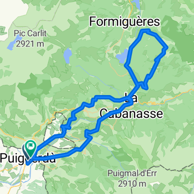
A cycling route starting in Puigcerdà, Catalonia, Spain.
Overview
About this route
R2: Puigcerda-Ventajola-Golf Fontanals-Alp-Prats-Bellver-Pi-Montella-Martinet-Lles-Ardovol-Prullans-Puigcerda.
- -:--
- Duration
- 67.4 km
- Distance
- 957 m
- Ascent
- 957 m
- Descent
- ---
- Avg. speed
- ---
- Avg. speed
Route quality
Waytypes & surfaces along the route
Waytypes
Quiet road
32.2 km
(48 %)
Busy road
22 km
(33 %)
Surfaces
Paved
25.8 km
(38 %)
Asphalt
25.8 km
(38 %)
Undefined
41.6 km
(62 %)
Continue with Bikemap
Use, edit, or download this cycling route
You would like to ride 2 Lles de Cerdanya or customize it for your own trip? Here is what you can do with this Bikemap route:
Free features
- Save this route as favorite or in collections
- Copy & plan your own version of this route
- Sync your route with Garmin or Wahoo
Premium features
Free trial for 3 days, or one-time payment. More about Bikemap Premium.
- Navigate this route on iOS & Android
- Export a GPX / KML file of this route
- Create your custom printout (try it for free)
- Download this route for offline navigation
Discover more Premium features.
Get Bikemap PremiumFrom our community
Other popular routes starting in Puigcerdà
 PORTÉ PUYMORENS - PORT D'ENVALIRA - PORTÉ PUYMORENS.
- Distance
- 85.8 km
- Ascent
- 2,102 m
- Descent
- 2,071 m
- Location
- Puigcerdà, Catalonia, Spain
 Ruta Puigcerdà -Pirineus francesos
- Distance
- 98.5 km
- Ascent
- 1,654 m
- Descent
- 1,657 m
- Location
- Puigcerdà, Catalonia, Spain
 Tour du Carlit (Col de Pailhéres)
- Distance
- 146.6 km
- Ascent
- 2,733 m
- Descent
- 2,734 m
- Location
- Puigcerdà, Catalonia, Spain
 COLL DEL CALVARI-COL DE CREU-COLL DE LA LLOSE
- Distance
- 81.3 km
- Ascent
- 1,739 m
- Descent
- 1,780 m
- Location
- Puigcerdà, Catalonia, Spain
 Mmmmmmmjmükkk K K Mann Mick
- Distance
- 29.9 km
- Ascent
- 1,355 m
- Descent
- 1,589 m
- Location
- Puigcerdà, Catalonia, Spain
 Puigcerda - Angoustrine - Font Romeu - La Llagonne - Matemale - Coll de la Creu - Railleu - Ayguatebia - La Llagonne - Bolquere- Font Romeu - Egat - Esta
- Distance
- 100.8 km
- Ascent
- 1,772 m
- Descent
- 1,782 m
- Location
- Puigcerdà, Catalonia, Spain
 Volta per la Cerdanya Francesa
- Distance
- 101.6 km
- Ascent
- 1,181 m
- Descent
- 1,181 m
- Location
- Puigcerdà, Catalonia, Spain
 Ruta 3 Nacions (Catalunya - Andorra - Francia)
- Distance
- 139.8 km
- Ascent
- 1,875 m
- Descent
- 1,875 m
- Location
- Puigcerdà, Catalonia, Spain
Open it in the app