
RGA - ÉTAPE 4/7
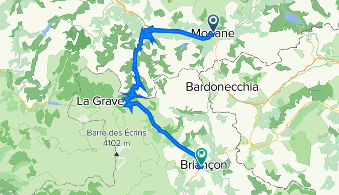
A cycling route starting in Modane, Auvergne-Rhône-Alpes, France.
Overview
About this route
- -:--
- Duration
- 89.2 km
- Distance
- 2,053 m
- Ascent
- 1,910 m
- Descent
- ---
- Avg. speed
- ---
- Avg. speed

Route quality
Waytypes & surfaces along the route
Waytypes
Busy road
75.6 km
(85 %)
Quiet road
5.6 km
(6 %)
Surfaces
Paved
72.1 km
(81 %)
Unpaved
0.8 km
(<1 %)
Asphalt
72.1 km
(81 %)
Gravel
0.5 km
(<1 %)
Route highlights
Points of interest along the route
Point of interest after 31 km
Col du Télégraphe - 1566 m
Point of interest after 32.8 km
Le Col - 1530 m
Point of interest after 53.2 km
Col du Galibier - 2642 m
Point of interest after 60.9 km
Col du Lautaret - 2057 m
Continue with Bikemap
Use, edit, or download this cycling route
You would like to ride RGA - ÉTAPE 4/7 or customize it for your own trip? Here is what you can do with this Bikemap route:
Free features
- Save this route as favorite or in collections
- Copy & plan your own version of this route
- Sync your route with Garmin or Wahoo
Premium features
Free trial for 3 days, or one-time payment. More about Bikemap Premium.
- Navigate this route on iOS & Android
- Export a GPX / KML file of this route
- Create your custom printout (try it for free)
- Download this route for offline navigation
Discover more Premium features.
Get Bikemap PremiumFrom our community
Other popular routes starting in Modane
 Francia_2018_4
- Distance
- 65.5 km
- Ascent
- 1,362 m
- Descent
- 1,923 m
- Location
- Modane, Auvergne-Rhône-Alpes, France
 Grandes Alpes_Kudrna_Etapa4
- Distance
- 94.5 km
- Ascent
- 2,050 m
- Descent
- 1,985 m
- Location
- Modane, Auvergne-Rhône-Alpes, France
 Tour de France 2015 - Stage 20
- Distance
- 113.6 km
- Ascent
- 2,809 m
- Descent
- 2,033 m
- Location
- Modane, Auvergne-Rhône-Alpes, France
 Route des Grandes Alpes 2010 - stage 4
- Distance
- 95.2 km
- Ascent
- 1,991 m
- Descent
- 1,904 m
- Location
- Modane, Auvergne-Rhône-Alpes, France
 MODANE GARE ORGERE AMODON MODANE
- Distance
- 25.8 km
- Ascent
- 920 m
- Descent
- 920 m
- Location
- Modane, Auvergne-Rhône-Alpes, France
 Tour de France 2016 dzień 10
- Distance
- 88.8 km
- Ascent
- 2,020 m
- Descent
- 1,898 m
- Location
- Modane, Auvergne-Rhône-Alpes, France
 Pavel, Dalibor super horst categori 2006
- Distance
- 221.3 km
- Ascent
- 4,906 m
- Descent
- 4,906 m
- Location
- Modane, Auvergne-Rhône-Alpes, France
 Francia Alpok 04 vándor
- Distance
- 101.1 km
- Ascent
- 2,009 m
- Descent
- 2,127 m
- Location
- Modane, Auvergne-Rhône-Alpes, France
Open it in the app