

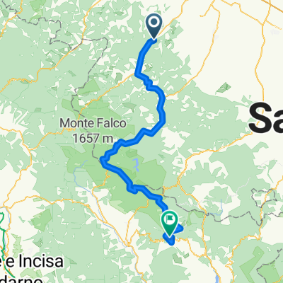
TAPPA 15: DOVADOLA - ROCCA SAN CASCIANO
A cycling route starting in Dovadola, Emilia-Romagna, Italy.
Overview
About this route
A Dovadola: Chiesa della SS Annunziata,Rocca dei Conti Guidi, Oratorio Sant'Antonio, Abbazia di Sant'Andrea, dormire, rifugio Beata Bianchi Porro. A Rocca San Casciano, Chiesa del Suffragio, Ponte Vecchio, Chiesa di S. Maria delle Lacrime.
- -:--
- Duration
- 8.3 km
- Distance
- 149 m
- Ascent
- 91 m
- Descent
- ---
- Avg. speed
- ---
- Avg. speed

Route quality
Waytypes & surfaces along the route
Waytypes
Busy road
4.7 km
(56 %)
Quiet road
3.6 km
(43 %)
Surfaces
Paved
4.1 km
(49 %)
Asphalt
4 km
(48 %)
Paved (undefined)
0.1 km
(<1 %)
Undefined
4.3 km
(51 %)
Continue with Bikemap
Use, edit, or download this cycling route
You would like to ride TAPPA 15: DOVADOLA - ROCCA SAN CASCIANO or customize it for your own trip? Here is what you can do with this Bikemap route:
Free features
- Save this route as favorite or in collections
- Copy & plan your own version of this route
- Sync your route with Garmin or Wahoo
Premium features
Free trial for 3 days, or one-time payment. More about Bikemap Premium.
- Navigate this route on iOS & Android
- Export a GPX / KML file of this route
- Create your custom printout (try it for free)
- Download this route for offline navigation
Discover more Premium features.
Get Bikemap PremiumFrom our community
Other popular routes starting in Dovadola
 TAPPA 15: DOVADOLA - ROCCA SAN CASCIANO
- Distance
- 8.3 km
- Ascent
- 149 m
- Descent
- 91 m
- Location
- Dovadola, Emilia-Romagna, Italy
 Variante Dovadola la Calla la Verna 106/2200
- Distance
- 106.8 km
- Ascent
- 2,694 m
- Descent
- 1,687 m
- Location
- Dovadola, Emilia-Romagna, Italy
 dovadola
- Distance
- 10.2 km
- Ascent
- 386 m
- Descent
- 386 m
- Location
- Dovadola, Emilia-Romagna, Italy
 Monte Colombo Calboli
- Distance
- 33 km
- Ascent
- 881 m
- Descent
- 884 m
- Location
- Dovadola, Emilia-Romagna, Italy
 Dovadola-SantaSofia
- Distance
- 53.7 km
- Ascent
- 1,007 m
- Descent
- 880 m
- Location
- Dovadola, Emilia-Romagna, Italy
 2018.2 Dovadola.Portico di Romagna v2
- Distance
- 32.8 km
- Ascent
- 824 m
- Descent
- 681 m
- Location
- Dovadola, Emilia-Romagna, Italy
 MTB Rocca San Casciano
- Distance
- 45.7 km
- Ascent
- 1,101 m
- Descent
- 1,034 m
- Location
- Dovadola, Emilia-Romagna, Italy
 Percorso Margherita con alcune varianti a Rocca San Casciano
- Distance
- 38.4 km
- Ascent
- 980 m
- Descent
- 980 m
- Location
- Dovadola, Emilia-Romagna, Italy
Open it in the app