

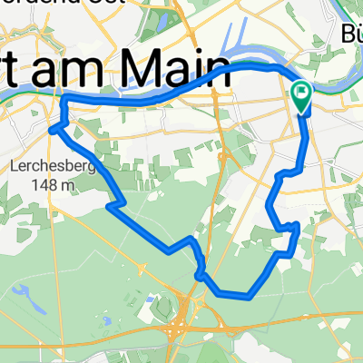
Frankfurt Oberrad - Stadtwald Seen -Main Tour
A cycling route starting in Offenbach, Hesse, Germany.
Overview
About this route
Eine schöne Fahrt beginnend im Stadtteil Oberrad in den Stadtwald relativ ebenerdig an mehreren Seen vorbei - die Rückfahrt geht am Mainufer entlang bis zum Ausgangspunkt
- -:--
- Duration
- 35.4 km
- Distance
- 89 m
- Ascent
- 89 m
- Descent
- ---
- Avg. speed
- ---
- Avg. speed
Route quality
Waytypes & surfaces along the route
Waytypes
Track
13.9 km
(39 %)
Path
8.5 km
(24 %)
Surfaces
Paved
21.9 km
(62 %)
Unpaved
13.1 km
(37 %)
Asphalt
18.7 km
(53 %)
Gravel
7.1 km
(20 %)
Continue with Bikemap
Use, edit, or download this cycling route
You would like to ride Frankfurt Oberrad - Stadtwald Seen -Main Tour or customize it for your own trip? Here is what you can do with this Bikemap route:
Free features
- Save this route as favorite or in collections
- Copy & plan your own version of this route
- Sync your route with Garmin or Wahoo
Premium features
Free trial for 3 days, or one-time payment. More about Bikemap Premium.
- Navigate this route on iOS & Android
- Export a GPX / KML file of this route
- Create your custom printout (try it for free)
- Download this route for offline navigation
Discover more Premium features.
Get Bikemap PremiumFrom our community
Other popular routes starting in Offenbach
 Von Park zu Park in Offenbach
- Distance
- 17.6 km
- Ascent
- 108 m
- Descent
- 108 m
- Location
- Offenbach, Hesse, Germany
 Rhein-Main-Runde
- Distance
- 158.2 km
- Ascent
- 522 m
- Descent
- 521 m
- Location
- Offenbach, Hesse, Germany
 Goetheturmfahrt
- Distance
- 18.5 km
- Ascent
- 85 m
- Descent
- 92 m
- Location
- Offenbach, Hesse, Germany
 110 Eschbacher Klippen Taunus
- Distance
- 108.5 km
- Ascent
- 885 m
- Descent
- 884 m
- Location
- Offenbach, Hesse, Germany
 08 - Maintal Schlösser und Parks
- Distance
- 24.7 km
- Ascent
- 66 m
- Descent
- 64 m
- Location
- Offenbach, Hesse, Germany
 Wetterau Rennrad
- Distance
- 48.3 km
- Ascent
- 175 m
- Descent
- 175 m
- Location
- Offenbach, Hesse, Germany
 Borsigallee, Frankfurt am Main nach An der Winkelsmühle, Dreieich
- Distance
- 19.8 km
- Ascent
- 151 m
- Descent
- 95 m
- Location
- Offenbach, Hesse, Germany
 OF-Götzemhain-Dietzenbach-Rodgau-OF
- Distance
- 37.4 km
- Ascent
- 123 m
- Descent
- 110 m
- Location
- Offenbach, Hesse, Germany
Open it in the app