
Vaals Amuseert
A cycling route starting in Aachen, North Rhine-Westphalia, Germany.
Overview
About this route
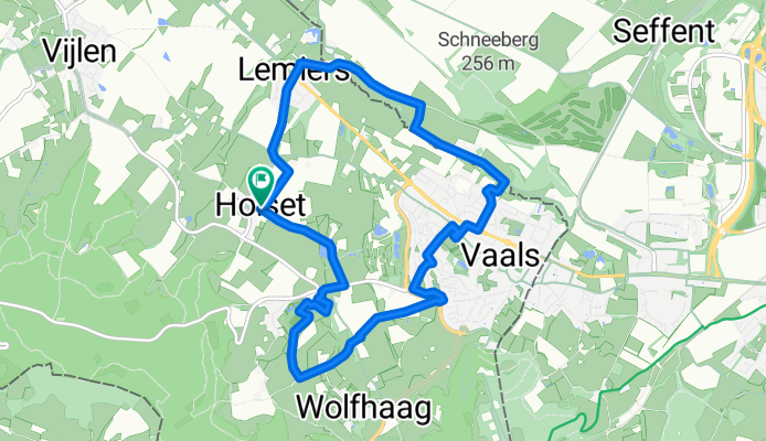
Genießen Sie einen schönen Tag im südlimburgischen Hügelland, burgundisch und historisch. Ein Wanderung von ca. 10,5 km Länge mit 4 verschiedenen Häppchen-Angeboten an 4 prächtigen Orten. Schlemmerhäppchen gibt es in Kasteel Bloemendal, Hoeve de Linde, Schloss Vaalsbroek und Herberg Oud Holset.
100 Hm, Dauer mit 4 Einkehren ca. 5 Stunden.
Anreise: Herberg Oud Holset, Holset 54, 6295 Lemiers
- -:--
- Duration
- 10.6 km
- Distance
- 138 m
- Ascent
- 138 m
- Descent
- ---
- Avg. speed
- ---
- Avg. speed

Continue with Bikemap
Use, edit, or download this cycling route
You would like to ride Vaals Amuseert or customize it for your own trip? Here is what you can do with this Bikemap route:
Free features
- Save this route as favorite or in collections
- Copy & plan your own version of this route
- Sync your route with Garmin or Wahoo
Premium features
Free trial for 3 days, or one-time payment. More about Bikemap Premium.
- Navigate this route on iOS & Android
- Export a GPX / KML file of this route
- Create your custom printout (try it for free)
- Download this route for offline navigation
Discover more Premium features.
Get Bikemap PremiumFrom our community
Other popular routes starting in Aachen
 aachen-zittau
- Distance
- 1,039.3 km
- Ascent
- 7,225 m
- Descent
- 7,135 m
- Location
- Aachen, North Rhine-Westphalia, Germany
 nice MTB route
- Distance
- 21.7 km
- Ascent
- 442 m
- Descent
- 450 m
- Location
- Aachen, North Rhine-Westphalia, Germany
 Zweifall +Hohes Venn
- Distance
- 69.6 km
- Ascent
- 564 m
- Descent
- 564 m
- Location
- Aachen, North Rhine-Westphalia, Germany
 Durchs Hohe Venn
- Distance
- 72.7 km
- Ascent
- 713 m
- Descent
- 589 m
- Location
- Aachen, North Rhine-Westphalia, Germany
 Aachen Süd, mit entspanntem Mittelstück
- Distance
- 14.5 km
- Ascent
- 257 m
- Descent
- 248 m
- Location
- Aachen, North Rhine-Westphalia, Germany
 Soers und Wurmtal
- Distance
- 16.1 km
- Ascent
- 145 m
- Descent
- 155 m
- Location
- Aachen, North Rhine-Westphalia, Germany
 Aachen-Maastricht-Aachen
- Distance
- 89.7 km
- Ascent
- 702 m
- Descent
- 702 m
- Location
- Aachen, North Rhine-Westphalia, Germany
 Köpfchen-Lichtenbusch-Vennbahn
- Distance
- 26.9 km
- Ascent
- 193 m
- Descent
- 174 m
- Location
- Aachen, North Rhine-Westphalia, Germany
Open it in the app