

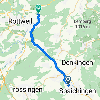
RW TR TUT SP
A cycling route starting in Spaichingen, Baden-Württemberg, Germany.
Overview
About this route
- -:--
- Duration
- 63.1 km
- Distance
- 376 m
- Ascent
- 378 m
- Descent
- ---
- Avg. speed
- ---
- Avg. speed

Route quality
Waytypes & surfaces along the route
Waytypes
Track
17.8 km
(28 %)
Quiet road
15 km
(24 %)
Surfaces
Paved
58.3 km
(92 %)
Unpaved
1.4 km
(2 %)
Asphalt
52 km
(82 %)
Paved (undefined)
5.7 km
(9 %)
Continue with Bikemap
Use, edit, or download this cycling route
You would like to ride RW TR TUT SP or customize it for your own trip? Here is what you can do with this Bikemap route:
Free features
- Save this route as favorite or in collections
- Copy & plan your own version of this route
- Sync your route with Garmin or Wahoo
Premium features
Free trial for 3 days, or one-time payment. More about Bikemap Premium.
- Navigate this route on iOS & Android
- Export a GPX / KML file of this route
- Create your custom printout (try it for free)
- Download this route for offline navigation
Discover more Premium features.
Get Bikemap PremiumFrom our community
Other popular routes starting in Spaichingen
 Durch den Schwarzwald nach Freiburg
- Distance
- 116.9 km
- Ascent
- 1,335 m
- Descent
- 1,723 m
- Location
- Spaichingen, Baden-Württemberg, Germany
 Spaichingen, Konzenberg und zurück
- Distance
- 22.2 km
- Ascent
- 107 m
- Descent
- 107 m
- Location
- Spaichingen, Baden-Württemberg, Germany
 RW TR TUT SP
- Distance
- 63.1 km
- Ascent
- 376 m
- Descent
- 378 m
- Location
- Spaichingen, Baden-Württemberg, Germany
 Spaichingen -- Klippeneck
- Distance
- 10.4 km
- Ascent
- 426 m
- Descent
- 132 m
- Location
- Spaichingen, Baden-Württemberg, Germany
 _Spaichingen bis hinter Oberlehen Stand 02.05.2020
- Distance
- 97.7 km
- Ascent
- 2,940 m
- Descent
- 2,456 m
- Location
- Spaichingen, Baden-Württemberg, Germany
 Rund Spaichingen
- Distance
- 24.4 km
- Ascent
- 216 m
- Descent
- 216 m
- Location
- Spaichingen, Baden-Württemberg, Germany
 Spaich.-Linsenb.
- Distance
- 15.2 km
- Ascent
- 51 m
- Descent
- 133 m
- Location
- Spaichingen, Baden-Württemberg, Germany
 Alter Berg, Glatter Fels, Schrofe
- Distance
- 34.7 km
- Ascent
- 634 m
- Descent
- 632 m
- Location
- Spaichingen, Baden-Württemberg, Germany
Open it in the app