

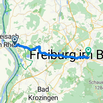
Auf zur Hohen Burg des Königs
A cycling route starting in Breisach, Baden-Württemberg, Germany.
Overview
About this route
Von Pfaffenweiler zur Hochkönigsburg im Elsass - zurück über Riegel und March. Route am Pfingstsamstag (22.05.2010) gefahren - Import direkt von Garmin-GPS-Forerunner.
- -:--
- Duration
- 168.8 km
- Distance
- 650 m
- Ascent
- 650 m
- Descent
- ---
- Avg. speed
- ---
- Avg. speed

Route quality
Waytypes & surfaces along the route
Waytypes
Busy road
43.8 km
(26 %)
Road
40.7 km
(24 %)
Surfaces
Paved
115.5 km
(68 %)
Unpaved
6.6 km
(4 %)
Asphalt
100.7 km
(60 %)
Paved (undefined)
13.5 km
(8 %)
Continue with Bikemap
Use, edit, or download this cycling route
You would like to ride Auf zur Hohen Burg des Königs or customize it for your own trip? Here is what you can do with this Bikemap route:
Free features
- Save this route as favorite or in collections
- Copy & plan your own version of this route
- Sync your route with Garmin or Wahoo
Premium features
Free trial for 3 days, or one-time payment. More about Bikemap Premium.
- Navigate this route on iOS & Android
- Export a GPX / KML file of this route
- Create your custom printout (try it for free)
- Download this route for offline navigation
Discover more Premium features.
Get Bikemap PremiumFrom our community
Other popular routes starting in Breisach
 Camembaertour 2003
- Distance
- 1,044.1 km
- Ascent
- 8,912 m
- Descent
- 9,093 m
- Location
- Breisach, Baden-Württemberg, Germany
 Auf zur Hohen Burg des Königs
- Distance
- 168.8 km
- Ascent
- 650 m
- Descent
- 650 m
- Location
- Breisach, Baden-Württemberg, Germany
 Münstertalrunde
- Distance
- 115.9 km
- Ascent
- 1,392 m
- Descent
- 1,392 m
- Location
- Breisach, Baden-Württemberg, Germany
 Elsass: Breisach/Schloss Rimsingen/Ihringen und zurück
- Distance
- 33.3 km
- Ascent
- 28 m
- Descent
- 28 m
- Location
- Breisach, Baden-Württemberg, Germany
 ausgedehnde Kaiserstuhlrunde
- Distance
- 57.3 km
- Ascent
- 89 m
- Descent
- 91 m
- Location
- Breisach, Baden-Württemberg, Germany
 Breisach-Freiburg
- Distance
- 22.6 km
- Ascent
- 140 m
- Descent
- 53 m
- Location
- Breisach, Baden-Württemberg, Germany
 ETAPPE 2 - Breisach nach Etupes
- Distance
- 109.9 km
- Ascent
- 377 m
- Descent
- 248 m
- Location
- Breisach, Baden-Württemberg, Germany
 MarckolsheimTrack_51Km
- Distance
- 50.8 km
- Ascent
- 68 m
- Descent
- 68 m
- Location
- Breisach, Baden-Württemberg, Germany
Open it in the app