
Route im Schneckentempo in Rimstin
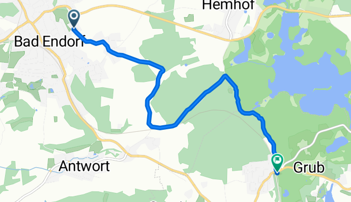
A cycling route starting in Bad Endorf, Bavaria, Germany.
Overview
About this route
- 24 min
- Duration
- 5.7 km
- Distance
- 58 m
- Ascent
- 68 m
- Descent
- 14.1 km/h
- Avg. speed
- ---
- Avg. speed

Route quality
Waytypes & surfaces along the route
Waytypes
Track
3.3 km
(59 %)
Quiet road
2 km
(35 %)
Surfaces
Paved
2.4 km
(42 %)
Unpaved
3.1 km
(55 %)
Asphalt
2.4 km
(42 %)
Gravel
1.7 km
(30 %)
Continue with Bikemap
Use, edit, or download this cycling route
You would like to ride Route im Schneckentempo in Rimstin or customize it for your own trip? Here is what you can do with this Bikemap route:
Free features
- Save this route as favorite or in collections
- Copy & plan your own version of this route
- Sync your route with Garmin or Wahoo
Premium features
Free trial for 3 days, or one-time payment. More about Bikemap Premium.
- Navigate this route on iOS & Android
- Export a GPX / KML file of this route
- Create your custom printout (try it for free)
- Download this route for offline navigation
Discover more Premium features.
Get Bikemap PremiumFrom our community
Other popular routes starting in Bad Endorf
 Ratzinger Höhe
- Distance
- 48 km
- Ascent
- 481 m
- Descent
- 481 m
- Location
- Bad Endorf, Bavaria, Germany
 Route nach Kirchplatz 2, Bad Endorf
- Distance
- 70.9 km
- Ascent
- 239 m
- Descent
- 243 m
- Location
- Bad Endorf, Bavaria, Germany
 Hemhof chiemsee Eggstätt
- Distance
- 21.3 km
- Ascent
- 129 m
- Descent
- 129 m
- Location
- Bad Endorf, Bavaria, Germany
 Schöne Runde, mit paar Steigungen
- Distance
- 53.1 km
- Ascent
- 435 m
- Descent
- 435 m
- Location
- Bad Endorf, Bavaria, Germany
 Samerberg Traumtour
- Distance
- 52.2 km
- Ascent
- 628 m
- Descent
- 626 m
- Location
- Bad Endorf, Bavaria, Germany
 Kesselsee und Langbürgner
- Distance
- 6.2 km
- Ascent
- 79 m
- Descent
- 79 m
- Location
- Bad Endorf, Bavaria, Germany
 Simssee-Runde 25km
- Distance
- 24.8 km
- Ascent
- 310 m
- Descent
- 312 m
- Location
- Bad Endorf, Bavaria, Germany
 Amerang
- Distance
- 42.3 km
- Ascent
- 339 m
- Descent
- 339 m
- Location
- Bad Endorf, Bavaria, Germany
Open it in the app