

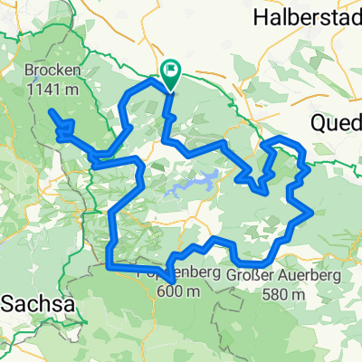
Harz: Zur Brockenspitze
A cycling route starting in Wernigerode, Saxony-Anhalt, Germany.
Overview
About this route
Von Wernigerode führt die Strecke zunächst in den Ortsteil Hasserode. Dort geleiten Wanderwege durch den Wald und nach „Drei Annen Hohne“, einem Bahnhof der Brockenbahn. Von dort wählen besonders Mountainbiker gern den welligen und wurzeligen Glashüttenweg. In Schierke bietet der Bahnhof die Möglichkeit zur Rast, ein kurzer Abstecher führt zur imposanten Feuersteinklippe. Der weitere Weg verläuft parallel der Bahngleise und mündet in die Brockenstraße. Sie beinhaltet mehrere kurze Steilstücke und endet auf dem Gipfelplateau hoch über dem Harz.
- -:--
- Duration
- 27.4 km
- Distance
- 1,018 m
- Ascent
- 123 m
- Descent
- ---
- Avg. speed
- ---
- Avg. speed

Route photos

Route quality
Waytypes & surfaces along the route
Waytypes
Track
13.7 km
(50 %)
Quiet road
9.7 km
(36 %)
Surfaces
Paved
11.5 km
(42 %)
Unpaved
14.7 km
(54 %)
Loose gravel
9.8 km
(36 %)
Asphalt
9.7 km
(35 %)
Continue with Bikemap
Use, edit, or download this cycling route
You would like to ride Harz: Zur Brockenspitze or customize it for your own trip? Here is what you can do with this Bikemap route:
Free features
- Save this route as favorite or in collections
- Copy & plan your own version of this route
- Sync your route with Garmin or Wahoo
Premium features
Free trial for 3 days, or one-time payment. More about Bikemap Premium.
- Navigate this route on iOS & Android
- Export a GPX / KML file of this route
- Create your custom printout (try it for free)
- Download this route for offline navigation
Discover more Premium features.
Get Bikemap PremiumFrom our community
Other popular routes starting in Wernigerode
 Zanthiersteintour
- Distance
- 22 km
- Ascent
- 447 m
- Descent
- 444 m
- Location
- Wernigerode, Saxony-Anhalt, Germany
 Große Dammstraße 32, Wernigerode nach Große Dammstraße 32, Wernigerode
- Distance
- 16.5 km
- Ascent
- 16 m
- Descent
- 7 m
- Location
- Wernigerode, Saxony-Anhalt, Germany
 Wernigerode: Brocken rauf und runter
- Distance
- 57.5 km
- Ascent
- 1,079 m
- Descent
- 1,078 m
- Location
- Wernigerode, Saxony-Anhalt, Germany
 Brockentour
- Distance
- 39.9 km
- Ascent
- 1,133 m
- Descent
- 977 m
- Location
- Wernigerode, Saxony-Anhalt, Germany
 Wernigerode - Allrode - Brocken / 126 km / 1705 HM
- Distance
- 123.7 km
- Ascent
- 1,339 m
- Descent
- 1,338 m
- Location
- Wernigerode, Saxony-Anhalt, Germany
 Brockenrunde
- Distance
- 153 km
- Ascent
- 2,210 m
- Descent
- 2,116 m
- Location
- Wernigerode, Saxony-Anhalt, Germany
 Brocken
- Distance
- 19.3 km
- Ascent
- 1,037 m
- Descent
- 157 m
- Location
- Wernigerode, Saxony-Anhalt, Germany
 Wernigerode - Brocken - Bad Harzburg - Wernigerode
- Distance
- 91.4 km
- Ascent
- 1,313 m
- Descent
- 1,313 m
- Location
- Wernigerode, Saxony-Anhalt, Germany
Open it in the app