
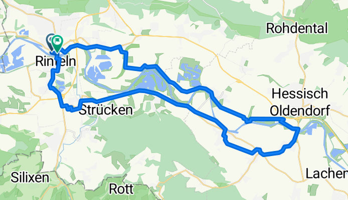
Rinteln Rundweg über Hessisch-Oldendorf 32km
A cycling route starting in Rinteln, Lower Saxony, Germany.
Overview
About this route
- -:--
- Duration
- 33.4 km
- Distance
- 56 m
- Ascent
- 52 m
- Descent
- ---
- Avg. speed
- ---
- Avg. speed

Route quality
Waytypes & surfaces along the route
Waytypes
Quiet road
10.5 km
(31 %)
Path
7.7 km
(23 %)
Surfaces
Paved
30.7 km
(92 %)
Unpaved
1.2 km
(4 %)
Asphalt
22.7 km
(68 %)
Paving stones
4.8 km
(14 %)
Continue with Bikemap
Use, edit, or download this cycling route
You would like to ride Rinteln Rundweg über Hessisch-Oldendorf 32km or customize it for your own trip? Here is what you can do with this Bikemap route:
Free features
- Save this route as favorite or in collections
- Copy & plan your own version of this route
- Sync your route with Garmin or Wahoo
Premium features
Free trial for 3 days, or one-time payment. More about Bikemap Premium.
- Navigate this route on iOS & Android
- Export a GPX / KML file of this route
- Create your custom printout (try it for free)
- Download this route for offline navigation
Discover more Premium features.
Get Bikemap PremiumFrom our community
Other popular routes starting in Rinteln
 Rinteln - Hameln
- Distance
- 54.8 km
- Ascent
- 65 m
- Descent
- 64 m
- Location
- Rinteln, Lower Saxony, Germany
 Exten - Silixen - Langenholzhausen -Rundfahrt
- Distance
- 28.4 km
- Ascent
- 275 m
- Descent
- 278 m
- Location
- Rinteln, Lower Saxony, Germany
 Auf dem höchsten Punkt am Ludwigsturm eine super Aussicht
- Distance
- 22 km
- Ascent
- 357 m
- Descent
- 357 m
- Location
- Rinteln, Lower Saxony, Germany
 Ein bischen zum Trödeln
- Distance
- 39.9 km
- Ascent
- 489 m
- Descent
- 419 m
- Location
- Rinteln, Lower Saxony, Germany
 Am Weseranger 2, Rinteln nach Am Weseranger 2, Rinteln
- Distance
- 20.7 km
- Ascent
- 212 m
- Descent
- 211 m
- Location
- Rinteln, Lower Saxony, Germany
 Rinteln Hameln 1-61km
- Distance
- 60.3 km
- Ascent
- 74 m
- Descent
- 76 m
- Location
- Rinteln, Lower Saxony, Germany
 Vom Campingpark Kalletal über Vlotho, Veltheim und Möllenbeck
- Distance
- 34.7 km
- Ascent
- 178 m
- Descent
- 180 m
- Location
- Rinteln, Lower Saxony, Germany
 Rundweg Rinteln/Möllenbeck/Exten/Rinteln
- Distance
- 15.4 km
- Ascent
- 26 m
- Descent
- 26 m
- Location
- Rinteln, Lower Saxony, Germany
Open it in the app