

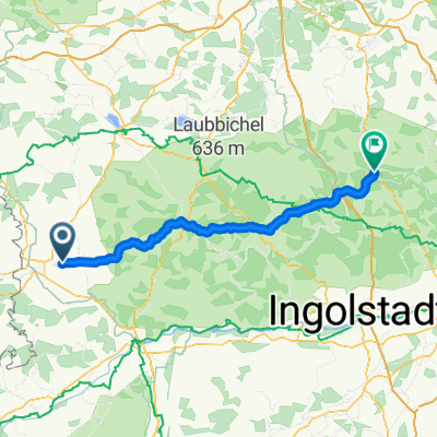
Nördlingen-Nürnberg, leicht-mittelschwere Route
A cycling route starting in Deiningen, Bavaria, Germany.
Overview
About this route
überwiegend ebenes bzw. flaches Gelände,
Rennradstrecke z.T. auf Radwegen und Straßen
ein schwieriger Anstieg bei Degersheim
- -:--
- Duration
- 109.3 km
- Distance
- 785 m
- Ascent
- 863 m
- Descent
- ---
- Avg. speed
- 634 m
- Avg. speed
Route quality
Waytypes & surfaces along the route
Waytypes
Road
44.1 km
(40 %)
Busy road
19.8 km
(18 %)
Surfaces
Paved
62.9 km
(58 %)
Unpaved
6.1 km
(6 %)
Asphalt
57 km
(52 %)
Paved (undefined)
5.2 km
(5 %)
Continue with Bikemap
Use, edit, or download this cycling route
You would like to ride Nördlingen-Nürnberg, leicht-mittelschwere Route or customize it for your own trip? Here is what you can do with this Bikemap route:
Free features
- Save this route as favorite or in collections
- Copy & plan your own version of this route
- Sync your route with Garmin or Wahoo
Premium features
Free trial for 3 days, or one-time payment. More about Bikemap Premium.
- Navigate this route on iOS & Android
- Export a GPX / KML file of this route
- Create your custom printout (try it for free)
- Download this route for offline navigation
Discover more Premium features.
Get Bikemap PremiumFrom our community
Other popular routes starting in Deiningen
 Dorfstraße 37, Nördlingen nach Ried 33–34, Donauwörth
- Distance
- 34.2 km
- Ascent
- 208 m
- Descent
- 217 m
- Location
- Deiningen, Bavaria, Germany
 Bachstraße 5, Nördlingen nach Wald-Seezentrum 1, Gunzenhausen
- Distance
- 36.3 km
- Ascent
- 184 m
- Descent
- 188 m
- Location
- Deiningen, Bavaria, Germany
 Route in Nördlingen
- Distance
- 6.5 km
- Ascent
- 17 m
- Descent
- 9 m
- Location
- Deiningen, Bavaria, Germany
 Deiningen- Beilngries
- Distance
- 84.5 km
- Ascent
- 390 m
- Descent
- 444 m
- Location
- Deiningen, Bavaria, Germany
 Pfäfflingen-Harburg-Wolferstadt
- Distance
- 70.6 km
- Ascent
- 746 m
- Descent
- 749 m
- Location
- Deiningen, Bavaria, Germany
 Nordries
- Distance
- 45.3 km
- Ascent
- 310 m
- Descent
- 288 m
- Location
- Deiningen, Bavaria, Germany
 Einfache Fahrt in Alerheim
- Distance
- 4.5 km
- Ascent
- 4 m
- Descent
- 12 m
- Location
- Deiningen, Bavaria, Germany
 Trans Alp 2018 Aufgabe
- Distance
- 52.2 km
- Ascent
- 560 m
- Descent
- 560 m
- Location
- Deiningen, Bavaria, Germany
Open it in the app