
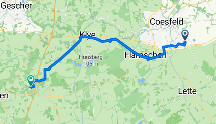
Anglerteiche Hochmoor, Hinweg kurz 16 km
A cycling route starting in Coesfeld, North Rhine-Westphalia, Germany.
Overview
About this route
durchs Gewerbegebiet, bei Boer vorbei, Richtung Freilichtbühne, Goxel, alten Radweg weiter Richtung Hochmoor
- -:--
- Duration
- 16.1 km
- Distance
- 43 m
- Ascent
- 69 m
- Descent
- ---
- Avg. speed
- ---
- Avg. speed
Route quality
Waytypes & surfaces along the route
Waytypes
Quiet road
12.8 km
(80 %)
Track
1.9 km
(12 %)
Surfaces
Paved
8.5 km
(53 %)
Unpaved
1.2 km
(8 %)
Asphalt
8.4 km
(52 %)
Gravel
1.2 km
(8 %)
Continue with Bikemap
Use, edit, or download this cycling route
You would like to ride Anglerteiche Hochmoor, Hinweg kurz 16 km or customize it for your own trip? Here is what you can do with this Bikemap route:
Free features
- Save this route as favorite or in collections
- Copy & plan your own version of this route
- Sync your route with Garmin or Wahoo
Premium features
Free trial for 3 days, or one-time payment. More about Bikemap Premium.
- Navigate this route on iOS & Android
- Export a GPX / KML file of this route
- Create your custom printout (try it for free)
- Download this route for offline navigation
Discover more Premium features.
Get Bikemap PremiumFrom our community
Other popular routes starting in Coesfeld
 KREUZWEG TOUR
- Distance
- 15.5 km
- Ascent
- 48 m
- Descent
- 46 m
- Location
- Coesfeld, North Rhine-Westphalia, Germany
 Rietmannweg 39, Coesfeld nach Rietmannweg 20, Coesfeld
- Distance
- 14.1 km
- Ascent
- 134 m
- Descent
- 133 m
- Location
- Coesfeld, North Rhine-Westphalia, Germany
 Coesf.-Lette u. zurück
- Distance
- 13.9 km
- Ascent
- 35 m
- Descent
- 37 m
- Location
- Coesfeld, North Rhine-Westphalia, Germany
 DLRG Maria-Veen Eis-Lounge Hinweg 15 km
- Distance
- 15.8 km
- Ascent
- 28 m
- Descent
- 51 m
- Location
- Coesfeld, North Rhine-Westphalia, Germany
 2-Schlösser-Route Darfeld-Varlar 35 Km
- Distance
- 35.1 km
- Ascent
- 149 m
- Descent
- 149 m
- Location
- Coesfeld, North Rhine-Westphalia, Germany
 RTF Coesfeld 112km 2009
- Distance
- 115.5 km
- Ascent
- 500 m
- Descent
- 490 m
- Location
- Coesfeld, North Rhine-Westphalia, Germany
 Windmühlenradweg 48 km
- Distance
- 44.9 km
- Ascent
- 136 m
- Descent
- 135 m
- Location
- Coesfeld, North Rhine-Westphalia, Germany
 Cafe Blumenkränzchen, Nottuln Hinweg 16 km
- Distance
- 15.5 km
- Ascent
- 151 m
- Descent
- 134 m
- Location
- Coesfeld, North Rhine-Westphalia, Germany