

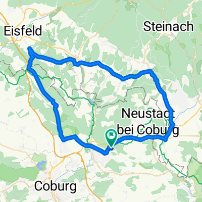
Rödental -Coburg - Itzgrung
A cycling route starting in Rödental, Bavaria, Germany.
Overview
About this route
Von Rödental in den Itzgrund. Viel Radwege, relativ flach.
Fortsetzung nach bamberg folgt.
- -:--
- Duration
- 28.3 km
- Distance
- 75 m
- Ascent
- 128 m
- Descent
- ---
- Avg. speed
- ---
- Avg. speed
Route quality
Waytypes & surfaces along the route
Waytypes
Quiet road
7.3 km
(26 %)
Track
6.2 km
(22 %)
Surfaces
Paved
21.9 km
(77 %)
Asphalt
21.6 km
(76 %)
Paved (undefined)
0.2 km
(<1 %)
Continue with Bikemap
Use, edit, or download this cycling route
You would like to ride Rödental -Coburg - Itzgrung or customize it for your own trip? Here is what you can do with this Bikemap route:
Free features
- Save this route as favorite or in collections
- Copy & plan your own version of this route
- Sync your route with Garmin or Wahoo
Premium features
Free trial for 3 days, or one-time payment. More about Bikemap Premium.
- Navigate this route on iOS & Android
- Export a GPX / KML file of this route
- Create your custom printout (try it for free)
- Download this route for offline navigation
Discover more Premium features.
Get Bikemap PremiumFrom our community
Other popular routes starting in Rödental
 Rund um die Veste Coburg
- Distance
- 59.1 km
- Ascent
- 213 m
- Descent
- 213 m
- Location
- Rödental, Bavaria, Germany
 Kleine Runde gegen Pfunde.
- Distance
- 22.8 km
- Ascent
- 135 m
- Descent
- 135 m
- Location
- Rödental, Bavaria, Germany
 durchs Laudertal und Rödental rund um die Schaumburg
- Distance
- 54.8 km
- Ascent
- 475 m
- Descent
- 475 m
- Location
- Rödental, Bavaria, Germany
 Rund um die Rosenau
- Distance
- 15.4 km
- Ascent
- 134 m
- Descent
- 134 m
- Location
- Rödental, Bavaria, Germany
 Auf der Werrabahntrasse zur Werraquelle und die Itz entlang
- Distance
- 65 km
- Ascent
- 653 m
- Descent
- 653 m
- Location
- Rödental, Bavaria, Germany
 Thüringisch-Fränkische Begegnung
- Distance
- 67.1 km
- Ascent
- 704 m
- Descent
- 708 m
- Location
- Rödental, Bavaria, Germany
 4Tälerweg -Röden-Itz-Lauter-Rodach
- Distance
- 39.6 km
- Ascent
- 551 m
- Descent
- 554 m
- Location
- Rödental, Bavaria, Germany
 Rund um Blumenrod
- Distance
- 22.6 km
- Ascent
- 226 m
- Descent
- 216 m
- Location
- Rödental, Bavaria, Germany
Open it in the app