

Wroxall Route XC & Road Combi
A cycling route starting in Ventnor, England, United Kingdom.
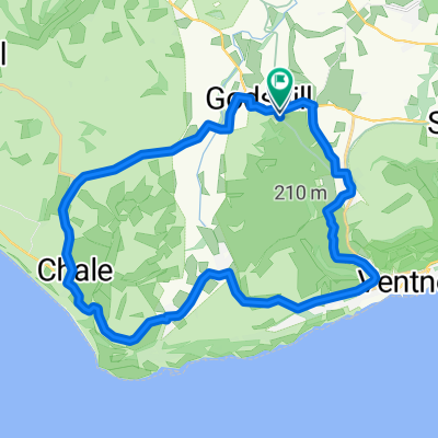
Overview
About this route
- -:--
- Duration
- 23.5 km
- Distance
- 153 m
- Ascent
- 166 m
- Descent
- ---
- Avg. speed
- ---
- Avg. speed

Route quality
Waytypes & surfaces along the route
Waytypes
Busy road
8.5 km
(36 %)
Road
7.4 km
(32 %)
Surfaces
Paved
19.4 km
(83 %)
Unpaved
3.2 km
(14 %)
Asphalt
18.9 km
(81 %)
Gravel
1.9 km
(8 %)
Continue with Bikemap
Use, edit, or download this cycling route
You would like to ride Wroxall Route XC & Road Combi or customize it for your own trip? Here is what you can do with this Bikemap route:
Free features
- Save this route as favorite or in collections
- Copy & plan your own version of this route
- Sync your route with Garmin or Wahoo
Premium features
Free trial for 3 days, or one-time payment. More about Bikemap Premium.
- Navigate this route on iOS & Android
- Export a GPX / KML file of this route
- Create your custom printout (try it for free)
- Download this route for offline navigation
Discover more Premium features.
Get Bikemap PremiumFrom our community
Other popular routes starting in Ventnor
 Little Loop
- Distance
- 20.2 km
- Ascent
- 135 m
- Descent
- 136 m
- Location
- Ventnor, England, United Kingdom
 Isle of Wight 109km
- Distance
- 109 km
- Ascent
- 608 m
- Descent
- 608 m
- Location
- Ventnor, England, United Kingdom
 Chalk Ridge Extreme Route
- Distance
- 93.2 km
- Ascent
- 1,115 m
- Descent
- 1,114 m
- Location
- Ventnor, England, United Kingdom
 Wroxall - Brading Loop
- Distance
- 22.5 km
- Ascent
- 288 m
- Descent
- 288 m
- Location
- Ventnor, England, United Kingdom
 IOW 17 mile
- Distance
- 25.6 km
- Ascent
- 252 m
- Descent
- 263 m
- Location
- Ventnor, England, United Kingdom
 Chillerton Tour - Via Whitwell & Roud
- Distance
- 35.4 km
- Ascent
- 347 m
- Descent
- 348 m
- Location
- Ventnor, England, United Kingdom
 Wroxall Rookley Wroxall
- Distance
- 22.4 km
- Ascent
- 207 m
- Descent
- 195 m
- Location
- Ventnor, England, United Kingdom
 Almost 20 mile loop
- Distance
- 32.1 km
- Ascent
- 446 m
- Descent
- 444 m
- Location
- Ventnor, England, United Kingdom
Open it in the app