
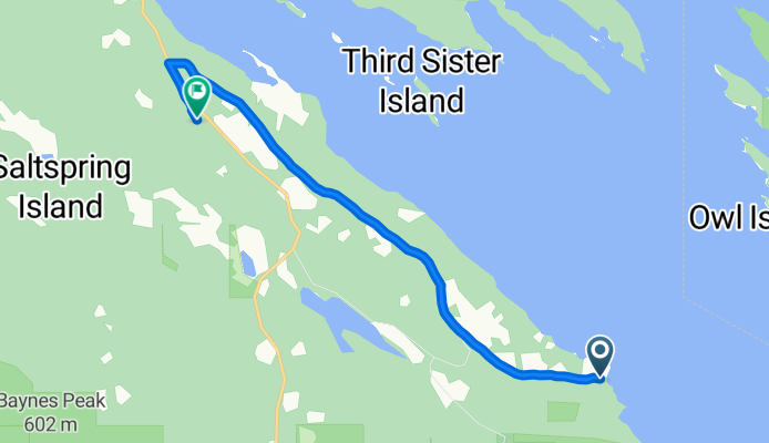
DAY 2 - Beach was great....hills not so much
A cycling route starting in North Saanich, British Columbia, Canada.
Overview
About this route
- 36 min
- Duration
- 7.7 km
- Distance
- 196 m
- Ascent
- 88 m
- Descent
- 13 km/h
- Avg. speed
- ---
- Avg. speed
Route quality
Waytypes & surfaces along the route
Waytypes
Quiet road
7.6 km
(99 %)
Busy road
0.1 km
(1 %)
Road
0 km
(<1 %)
Surfaces
Paved
7.5 km
(98 %)
Paved (undefined)
7.4 km
(97 %)
Asphalt
0.1 km
(1 %)
Undefined
0.2 km
(2 %)
Continue with Bikemap
Use, edit, or download this cycling route
You would like to ride DAY 2 - Beach was great....hills not so much or customize it for your own trip? Here is what you can do with this Bikemap route:
Free features
- Save this route as favorite or in collections
- Copy & plan your own version of this route
- Sync your route with Garmin or Wahoo
Premium features
Free trial for 3 days, or one-time payment. More about Bikemap Premium.
- Navigate this route on iOS & Android
- Export a GPX / KML file of this route
- Create your custom printout (try it for free)
- Download this route for offline navigation
Discover more Premium features.
Get Bikemap PremiumFrom our community
Other popular routes starting in North Saanich
 Swartz Bay Cowichan Lake Loop
- Distance
- 296.4 km
- Ascent
- 1,218 m
- Descent
- 1,210 m
- Location
- North Saanich, British Columbia, Canada
 Day 3 of Summer 2008 Tour (Sidney, BC to Ladysmith via Mill Bay)
- Distance
- 95 km
- Ascent
- 610 m
- Descent
- 571 m
- Location
- North Saanich, British Columbia, Canada
 Patricia Bay Highway 11300, Sidney to British Columbia 1 3140, Victoria
- Distance
- 39.5 km
- Ascent
- 330 m
- Descent
- 318 m
- Location
- North Saanich, British Columbia, Canada
 Top Of Old Mt Baldy
- Distance
- 22.2 km
- Ascent
- 663 m
- Descent
- 659 m
- Location
- North Saanich, British Columbia, Canada
 Mill Bay - Cobble Hill Loop
- Distance
- 26 km
- Ascent
- 273 m
- Descent
- 273 m
- Location
- North Saanich, British Columbia, Canada
 The Water Tower Is Gone
- Distance
- 17.1 km
- Ascent
- 445 m
- Descent
- 473 m
- Location
- North Saanich, British Columbia, Canada
 Full Quad Trail Loop
- Distance
- 28.7 km
- Ascent
- 607 m
- Descent
- 600 m
- Location
- North Saanich, British Columbia, Canada
 Mary Winspear Parking Lot to Ferry Terminal
- Distance
- 5.6 km
- Ascent
- 53 m
- Descent
- 36 m
- Location
- North Saanich, British Columbia, Canada
Open it in the app