

Day 1
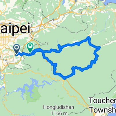
A cycling route starting in Taipei, Taipei, Taiwan.
Overview
About this route
- -:--
- Duration
- 99 km
- Distance
- 85 m
- Ascent
- 69 m
- Descent
- ---
- Avg. speed
- ---
- Avg. speed

Route quality
Waytypes & surfaces along the route
Waytypes
Busy road
41.6 km
(42 %)
Cycleway
25.8 km
(26 %)
Surfaces
Paved
5.8 km
(6 %)
Asphalt
5 km
(5 %)
Concrete
0.7 km
(<1 %)
Route highlights
Points of interest along the route
Point of interest after 18.3 km
7-11
Point of interest after 45.3 km
7-11休息站
Point of interest after 59.5 km
ok
Point of interest after 67.6 km
lunch
Point of interest after 89.2 km
7-11
Continue with Bikemap
Use, edit, or download this cycling route
You would like to ride Day 1 or customize it for your own trip? Here is what you can do with this Bikemap route:
Free features
- Save this route as favorite or in collections
- Copy & plan your own version of this route
- Sync your route with Garmin or Wahoo
Premium features
Free trial for 3 days, or one-time payment. More about Bikemap Premium.
- Navigate this route on iOS & Android
- Export a GPX / KML file of this route
- Create your custom printout (try it for free)
- Download this route for offline navigation
Discover more Premium features.
Get Bikemap PremiumFrom our community
Other popular routes starting in Taipei
 小鐵人宜蘭兩日20160423
- Distance
- 89.5 km
- Ascent
- 585 m
- Descent
- 589 m
- Location
- Taipei, Taipei, Taiwan
 陽金3P
陽金3P- Distance
- 114.6 km
- Ascent
- 2,046 m
- Descent
- 1,741 m
- Location
- Taipei, Taipei, Taiwan
 ironkidz_201510_微風車訓_FINAL
- Distance
- 40.1 km
- Ascent
- 73 m
- Descent
- 73 m
- Location
- Taipei, Taipei, Taiwan
 Taiwan tour
- Distance
- 985.3 km
- Ascent
- 1,195 m
- Descent
- 1,194 m
- Location
- Taipei, Taipei, Taiwan
 Short bike tour through Taipei City
- Distance
- 3.2 km
- Ascent
- 295 m
- Descent
- 295 m
- Location
- Taipei, Taipei, Taiwan
 台北←→桃園三坑老街
- Distance
- 111 km
- Ascent
- 321 m
- Descent
- 315 m
- Location
- Taipei, Taipei, Taiwan
 秘境之旅-南港,汐止,平溪,石碇
- Distance
- 66.8 km
- Ascent
- 1,419 m
- Descent
- 1,418 m
- Location
- Taipei, Taipei, Taiwan
 系列七 海王星-闊瀨尋奇
- Distance
- 82.8 km
- Ascent
- 1,299 m
- Descent
- 1,281 m
- Location
- Taipei, Taipei, Taiwan
Open it in the app