

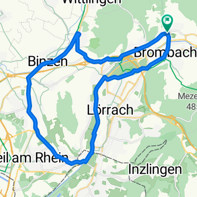
Ottwangen-Runde
A cycling route starting in Steinen, Baden-Württemberg, Germany.
Overview
About this route
- 58 min
- Duration
- 16.6 km
- Distance
- 230 m
- Ascent
- 231 m
- Descent
- 17.2 km/h
- Avg. speed
- ---
- Avg. speed
Route quality
Waytypes & surfaces along the route
Waytypes
Quiet road
6.3 km
(38 %)
Road
6.2 km
(38 %)
Surfaces
Paved
12 km
(73 %)
Unpaved
0.4 km
(2 %)
Asphalt
11.1 km
(67 %)
Paved (undefined)
0.9 km
(6 %)
Continue with Bikemap
Use, edit, or download this cycling route
You would like to ride Ottwangen-Runde or customize it for your own trip? Here is what you can do with this Bikemap route:
Free features
- Save this route as favorite or in collections
- Copy & plan your own version of this route
- Sync your route with Garmin or Wahoo
Premium features
Free trial for 3 days, or one-time payment. More about Bikemap Premium.
- Navigate this route on iOS & Android
- Export a GPX / KML file of this route
- Create your custom printout (try it for free)
- Download this route for offline navigation
Discover more Premium features.
Get Bikemap PremiumFrom our community
Other popular routes starting in Steinen
 Abendrunde um den Tüllinger Berg
- Distance
- 22.1 km
- Ascent
- 157 m
- Descent
- 161 m
- Location
- Steinen, Baden-Württemberg, Germany
 tour am 29.08.
- Distance
- 24.4 km
- Ascent
- 423 m
- Descent
- 409 m
- Location
- Steinen, Baden-Württemberg, Germany
 Wiesental-Hotzenwald-Tour
- Distance
- 106.3 km
- Ascent
- 0 m
- Descent
- 0 m
- Location
- Steinen, Baden-Württemberg, Germany
 Steinen-Brombach-Römerweg
- Distance
- 29 km
- Ascent
- 498 m
- Descent
- 497 m
- Location
- Steinen, Baden-Württemberg, Germany
 RR-Stei-Schl-Muelle-Feldb-Ka-Stei
- Distance
- 69.4 km
- Ascent
- 715 m
- Descent
- 715 m
- Location
- Steinen, Baden-Württemberg, Germany
 Brombach - Basel (mein Arbeitsweg)
- Distance
- 13 km
- Ascent
- 19 m
- Descent
- 121 m
- Location
- Steinen, Baden-Württemberg, Germany
 Steinen-Brombach-Rührberg-Herten-Degerfelden-Eichberg-Hüsingen-Steinen
- Distance
- 37.2 km
- Ascent
- 624 m
- Descent
- 625 m
- Location
- Steinen, Baden-Württemberg, Germany
 Thomas tour
- Distance
- 45.2 km
- Ascent
- 752 m
- Descent
- 752 m
- Location
- Steinen, Baden-Württemberg, Germany
Open it in the app