

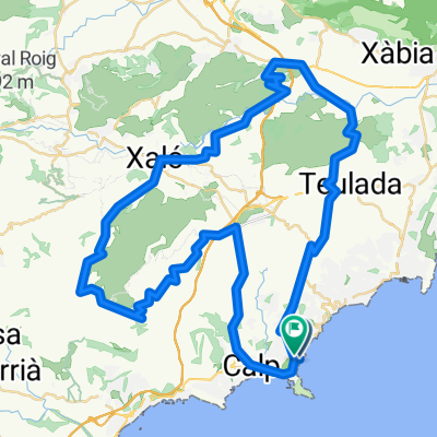
La Marina Alta: de Calp al mirador de Toix
A cycling route starting in Calpe, Valencia, Spain.
Overview
About this route
Pujada al morro de Toix per la carretera del Port Blanc i baixada per la general. Excel·lents vistes.
- -:--
- Duration
- 12.9 km
- Distance
- 316 m
- Ascent
- 314 m
- Descent
- ---
- Avg. speed
- ---
- Avg. speed

Route photos


Continue with Bikemap
Use, edit, or download this cycling route
You would like to ride La Marina Alta: de Calp al mirador de Toix or customize it for your own trip? Here is what you can do with this Bikemap route:
Free features
- Save this route as favorite or in collections
- Copy & plan your own version of this route
- Sync your route with Garmin or Wahoo
Premium features
Free trial for 3 days, or one-time payment. More about Bikemap Premium.
- Navigate this route on iOS & Android
- Export a GPX / KML file of this route
- Create your custom printout (try it for free)
- Download this route for offline navigation
Discover more Premium features.
Get Bikemap PremiumFrom our community
Other popular routes starting in Calpe
 Calpe rit 74km
- Distance
- 74.6 km
- Ascent
- 1,005 m
- Descent
- 1,000 m
- Location
- Calpe, Valencia, Spain
 Recovery
- Distance
- 61.1 km
- Ascent
- 1,136 m
- Descent
- 1,136 m
- Location
- Calpe, Valencia, Spain
 Calpe-Bernia 60km
- Distance
- 60 km
- Ascent
- 870 m
- Descent
- 867 m
- Location
- Calpe, Valencia, Spain
 Altea-Alfaz-Guadlest-Callosa
- Distance
- 55.7 km
- Ascent
- 935 m
- Descent
- 923 m
- Location
- Calpe, Valencia, Spain
 Astrik Calpe dag 1
- Distance
- 97.7 km
- Ascent
- 1,274 m
- Descent
- 1,274 m
- Location
- Calpe, Valencia, Spain
 Astrik Calpe dag 1
- Distance
- 100.1 km
- Ascent
- 1,377 m
- Descent
- 1,379 m
- Location
- Calpe, Valencia, Spain
 6- Astrik Calpe 2023 - dag 6 mandag
- Distance
- 58.6 km
- Ascent
- 869 m
- Descent
- 868 m
- Location
- Calpe, Valencia, Spain
 Calpé->Cumbre del sol ->Calpé
- Distance
- 37.3 km
- Ascent
- 622 m
- Descent
- 621 m
- Location
- Calpe, Valencia, Spain
Open it in the app