

Are you crazy?!
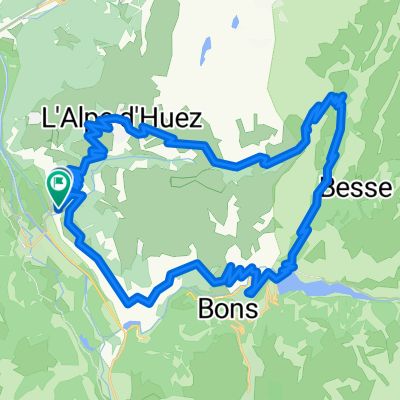
A cycling route starting in Huez, Auvergne-Rhône-Alpes, France.
Overview
About this route
via Col du Glandon naar Lacets du mont Vernier. Croix de Fer als afsluiter.
- -:--
- Duration
- 128.9 km
- Distance
- 3,244 m
- Ascent
- 3,244 m
- Descent
- ---
- Avg. speed
- ---
- Avg. speed

Route quality
Waytypes & surfaces along the route
Waytypes
Busy road
91.9 km
(71 %)
Road
22.3 km
(17 %)
Surfaces
Paved
50.1 km
(39 %)
Unpaved
1 km
(<1 %)
Asphalt
50.1 km
(39 %)
Gravel
0.8 km
(<1 %)
Continue with Bikemap
Use, edit, or download this cycling route
You would like to ride Are you crazy?! or customize it for your own trip? Here is what you can do with this Bikemap route:
Free features
- Save this route as favorite or in collections
- Copy & plan your own version of this route
- Sync your route with Garmin or Wahoo
Premium features
Free trial for 3 days, or one-time payment. More about Bikemap Premium.
- Navigate this route on iOS & Android
- Export a GPX / KML file of this route
- Create your custom printout (try it for free)
- Download this route for offline navigation
Discover more Premium features.
Get Bikemap PremiumFrom our community
Other popular routes starting in Huez
 Tour Alp Huez dia 2
- Distance
- 79 km
- Ascent
- 2,724 m
- Descent
- 2,722 m
- Location
- Huez, Auvergne-Rhône-Alpes, France
 Alpe d-Huez boucle
- Distance
- 48.9 km
- Ascent
- 1,639 m
- Descent
- 1,714 m
- Location
- Huez, Auvergne-Rhône-Alpes, France
 L'Alpe-d-Huez
- Distance
- 12.9 km
- Ascent
- 1,222 m
- Descent
- 94 m
- Location
- Huez, Auvergne-Rhône-Alpes, France
 Alpe d`Huez
- Distance
- 14.2 km
- Ascent
- 1,183 m
- Descent
- 70 m
- Location
- Huez, Auvergne-Rhône-Alpes, France
 Bourg d'Oisans - Bourg d'Oisans
- Distance
- 159.7 km
- Ascent
- 4,577 m
- Descent
- 3,464 m
- Location
- Huez, Auvergne-Rhône-Alpes, France
 Classic Climbs - Day 1b - Col Du Galibier
- Distance
- 47.2 km
- Ascent
- 2,437 m
- Descent
- 550 m
- Location
- Huez, Auvergne-Rhône-Alpes, France
 L'Alpe d'Huez
- Distance
- 60.3 km
- Ascent
- 1,850 m
- Descent
- 1,850 m
- Location
- Huez, Auvergne-Rhône-Alpes, France
 Mein La Marmotte 2010
- Distance
- 173.8 km
- Ascent
- 4,517 m
- Descent
- 3,432 m
- Location
- Huez, Auvergne-Rhône-Alpes, France
Open it in the app