

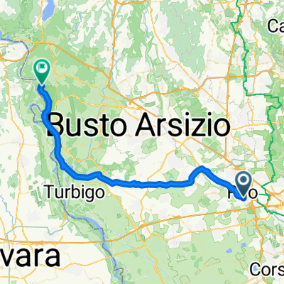
Ciclovia Valle Olona A/R
A cycling route starting in Rho, Lombardy, Italy.
Overview
About this route
Ex Ferrovia della Valmorea (Mendrisio [CH] - Stabio [CH] - Valmorea [IT] - Castellanza [IT])
Essa fu progettata alla fine dell'Ottocento per favorire lo smercio dei prodotti industriali della Valle dell'Olona verso la Svizzera. Il servizio internazionale cessò già nel 1928, nel 1952 quello passeggeri e nel 1977 il servizio merci.
La Pista Ciclabile inizia a Castellanza e termina a Castiglione Olona
*Tratti su trada
Destinazione: Castiglione Olona
- -:--
- Duration
- 76.2 km
- Distance
- 154 m
- Ascent
- 154 m
- Descent
- ---
- Avg. speed
- ---
- Max. altitude

Route quality
Waytypes & surfaces along the route
Waytypes
Cycleway
43.5 km
(57 %)
Quiet road
19.1 km
(25 %)
Surfaces
Paved
32.8 km
(43 %)
Unpaved
12.2 km
(16 %)
Asphalt
32 km
(42 %)
Ground
4.6 km
(6 %)
Continue with Bikemap
Use, edit, or download this cycling route
You would like to ride Ciclovia Valle Olona A/R or customize it for your own trip? Here is what you can do with this Bikemap route:
Free features
- Save this route as favorite or in collections
- Copy & plan your own version of this route
- Sync your route with Garmin or Wahoo
Premium features
Free trial for 3 days, or one-time payment. More about Bikemap Premium.
- Navigate this route on iOS & Android
- Export a GPX / KML file of this route
- Create your custom printout (try it for free)
- Download this route for offline navigation
Discover more Premium features.
Get Bikemap PremiumFrom our community
Other popular routes starting in Rho
 Opzione 1.2 - più compatta
- Distance
- 8.3 km
- Ascent
- 13 m
- Descent
- 15 m
- Location
- Rho, Lombardy, Italy
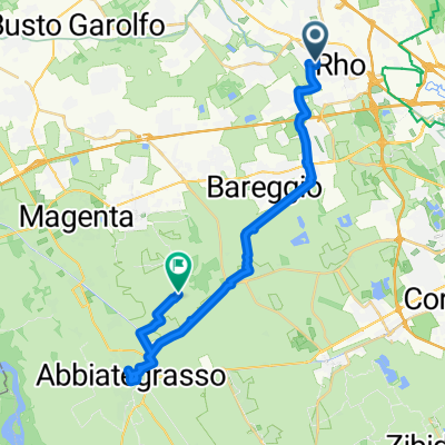 Rho - Abbiategrasso
- Distance
- 30.1 km
- Ascent
- 17 m
- Descent
- 53 m
- Location
- Rho, Lombardy, Italy
 Itinerario archeologico Rho
- Distance
- 12.4 km
- Ascent
- 25 m
- Descent
- 21 m
- Location
- Rho, Lombardy, Italy
 progetto finale bikemap
- Distance
- 19.9 km
- Ascent
- 49 m
- Descent
- 50 m
- Location
- Rho, Lombardy, Italy
 Percorso Naturalistico variante
- Distance
- 22 km
- Ascent
- 53 m
- Descent
- 52 m
- Location
- Rho, Lombardy, Italy
 Tour murales Rho variante
- Distance
- 7.7 km
- Ascent
- 28 m
- Descent
- 28 m
- Location
- Rho, Lombardy, Italy
 Rho - Diga del Panperduto
- Distance
- 45.8 km
- Ascent
- 118 m
- Descent
- 84 m
- Location
- Rho, Lombardy, Italy
 Itinerario archeologico Rho variante
- Distance
- 14.6 km
- Ascent
- 47 m
- Descent
- 49 m
- Location
- Rho, Lombardy, Italy
Open it in the app