
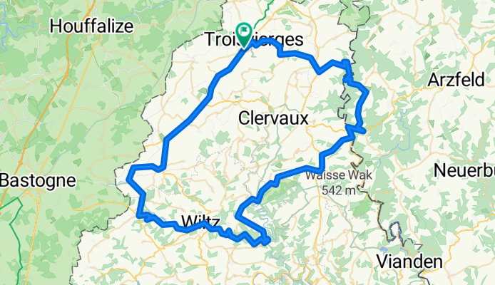
Hochplateaus TROISVIERGES-DASBURG-Tr.
A cycling route starting in Troisvierges, District de Diekirch, Luxembourg.
Overview
About this route
Die Strecke führt durch mehrere Täler, jedoch mit 5 Anstiegen von jeweils 200-250 Höhenmeter. Sie bietet wunderschöne Panoramabilder
- -:--
- Duration
- 91.7 km
- Distance
- 1,070 m
- Ascent
- 1,070 m
- Descent
- ---
- Avg. speed
- ---
- Avg. speed
Route quality
Waytypes & surfaces along the route
Waytypes
Busy road
74.6 km
(81 %)
Quiet road
7.8 km
(9 %)
Surfaces
Paved
81.2 km
(89 %)
Unpaved
1.9 km
(2 %)
Asphalt
79.5 km
(87 %)
Paved (undefined)
1.6 km
(2 %)
Continue with Bikemap
Use, edit, or download this cycling route
You would like to ride Hochplateaus TROISVIERGES-DASBURG-Tr. or customize it for your own trip? Here is what you can do with this Bikemap route:
Free features
- Save this route as favorite or in collections
- Copy & plan your own version of this route
- Sync your route with Garmin or Wahoo
Premium features
Free trial for 3 days, or one-time payment. More about Bikemap Premium.
- Navigate this route on iOS & Android
- Export a GPX / KML file of this route
- Create your custom printout (try it for free)
- Download this route for offline navigation
Discover more Premium features.
Get Bikemap PremiumFrom our community
Other popular routes starting in Troisvierges
 Huldange Hiwweleg
- Distance
- 38.9 km
- Ascent
- 432 m
- Descent
- 424 m
- Location
- Troisvierges, District de Diekirch, Luxembourg
 Untitled route
- Distance
- 122.2 km
- Ascent
- 1,542 m
- Descent
- 1,687 m
- Location
- Troisvierges, District de Diekirch, Luxembourg
 Aachen-San Sebastien (etappen 1-4)
- Distance
- 688.6 km
- Ascent
- 777 m
- Descent
- 1,166 m
- Location
- Troisvierges, District de Diekirch, Luxembourg
 3. Etappe: Massen-Troisvierges - Luxemburg
- Distance
- 88.7 km
- Ascent
- 1,118 m
- Descent
- 1,276 m
- Location
- Troisvierges, District de Diekirch, Luxembourg
 Along the Our
- Distance
- 46.6 km
- Ascent
- 392 m
- Descent
- 590 m
- Location
- Troisvierges, District de Diekirch, Luxembourg
 Panorama Tour
- Distance
- 24.5 km
- Ascent
- 321 m
- Descent
- 323 m
- Location
- Troisvierges, District de Diekirch, Luxembourg
 Sentiers Locaux_Ardennes Troisvierges-B, Troisvierges to CR 122, Imbringen
- Distance
- 112.6 km
- Ascent
- 2,286 m
- Descent
- 2,400 m
- Location
- Troisvierges, District de Diekirch, Luxembourg
 Vennbahn + Rursee + Maastricht + Liège
- Distance
- 242.9 km
- Ascent
- 862 m
- Descent
- 1,220 m
- Location
- Troisvierges, District de Diekirch, Luxembourg
Open it in the app