

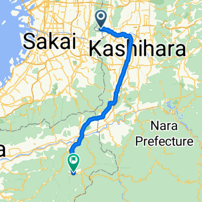
Shigisan to Koyasan
A cycling route starting in Kashihara, Ōsaka, Japan.
Overview
About this route
- -:--
- Duration
- 62.6 km
- Distance
- 1,238 m
- Ascent
- 696 m
- Descent
- ---
- Avg. speed
- ---
- Avg. speed

Route quality
Waytypes & surfaces along the route
Waytypes
Busy road
26 km
(42 %)
Quiet road
24.6 km
(39 %)
Surfaces
Paved
1.4 km
(2 %)
Paved (undefined)
1.4 km
(2 %)
Undefined
61.2 km
(98 %)
Continue with Bikemap
Use, edit, or download this cycling route
You would like to ride Shigisan to Koyasan or customize it for your own trip? Here is what you can do with this Bikemap route:
Free features
- Save this route as favorite or in collections
- Copy & plan your own version of this route
- Sync your route with Garmin or Wahoo
Premium features
Free trial for 3 days, or one-time payment. More about Bikemap Premium.
- Navigate this route on iOS & Android
- Export a GPX / KML file of this route
- Create your custom printout (try it for free)
- Download this route for offline navigation
Discover more Premium features.
Get Bikemap PremiumFrom our community
Other popular routes starting in Kashihara
 Shigisan to Koyasan
- Distance
- 62.6 km
- Ascent
- 1,238 m
- Descent
- 696 m
- Location
- Kashihara, Ōsaka, Japan
 大阪→岐阜
大阪→岐阜- Distance
- 185.2 km
- Ascent
- 1,160 m
- Descent
- 1,166 m
- Location
- Kashihara, Ōsaka, Japan
 3丁目, 八尾市 まで堺市
- Distance
- 15.2 km
- Ascent
- 37 m
- Descent
- 25 m
- Location
- Kashihara, Ōsaka, Japan
 3丁目, 八尾市 まで4丁目, 堺市
- Distance
- 17.5 km
- Ascent
- 50 m
- Descent
- 53 m
- Location
- Kashihara, Ōsaka, Japan
 ローソン杭全
- Distance
- 9.9 km
- Ascent
- 14 m
- Descent
- 21 m
- Location
- Kashihara, Ōsaka, Japan
 柏原市民文化会館 リビエールホール
- Distance
- 3.4 km
- Ascent
- 3 m
- Descent
- 0 m
- Location
- Kashihara, Ōsaka, Japan
 河内長野→狭山→堺
- Distance
- 56.5 km
- Ascent
- 449 m
- Descent
- 448 m
- Location
- Kashihara, Ōsaka, Japan
 ヴェロスタfastest
- Distance
- 15.9 km
- Ascent
- 39 m
- Descent
- 29 m
- Location
- Kashihara, Ōsaka, Japan
Open it in the app