

MENÉE, por Menée
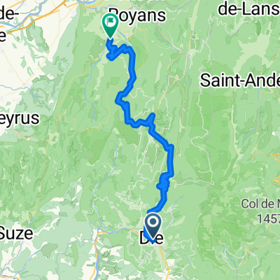
A cycling route starting in Die, Auvergne-Rhône-Alpes, France.
Overview
About this route
Subida.
- -:--
- Duration
- 15.1 km
- Distance
- 768 m
- Ascent
- 0 m
- Descent
- ---
- Avg. speed
- ---
- Avg. speed
Route quality
Waytypes & surfaces along the route
Waytypes
Busy road
15.1 km
(100 %)
Road
0 km
(<1 %)
Surfaces
Paved
7.8 km
(52 %)
Asphalt
7.8 km
(52 %)
Undefined
7.3 km
(48 %)
Continue with Bikemap
Use, edit, or download this cycling route
You would like to ride MENÉE, por Menée or customize it for your own trip? Here is what you can do with this Bikemap route:
Free features
- Save this route as favorite or in collections
- Copy & plan your own version of this route
- Sync your route with Garmin or Wahoo
Premium features
Free trial for 3 days, or one-time payment. More about Bikemap Premium.
- Navigate this route on iOS & Android
- Export a GPX / KML file of this route
- Create your custom printout (try it for free)
- Download this route for offline navigation
Discover more Premium features.
Get Bikemap PremiumFrom our community
Other popular routes starting in Die
 QuälDich Route 1 150km !!
- Distance
- 74.5 km
- Ascent
- 2,894 m
- Descent
- 3,082 m
- Location
- Die, Auvergne-Rhône-Alpes, France
 Route nach Avenue de la Clairette 90, Die
- Distance
- 40.4 km
- Ascent
- 1,166 m
- Descent
- 1,165 m
- Location
- Die, Auvergne-Rhône-Alpes, France
 Ouest de Die
- Distance
- 83.5 km
- Ascent
- 858 m
- Descent
- 859 m
- Location
- Die, Auvergne-Rhône-Alpes, France
 Alpentocht 2015 dag 2 Definitief
- Distance
- 97 km
- Ascent
- 2,122 m
- Descent
- 1,224 m
- Location
- Die, Auvergne-Rhône-Alpes, France
 Tour du Glandasse
- Distance
- 32.6 km
- Ascent
- 929 m
- Descent
- 933 m
- Location
- Die, Auvergne-Rhône-Alpes, France
 Vercheny - Col de Penne - Die
- Distance
- 48.9 km
- Ascent
- 946 m
- Descent
- 746 m
- Location
- Die, Auvergne-Rhône-Alpes, France
 FA13 Die St. Jean en Royans
- Distance
- 61.8 km
- Ascent
- 1,263 m
- Descent
- 1,423 m
- Location
- Die, Auvergne-Rhône-Alpes, France
 quäldich Route 2 150km
- Distance
- 73 km
- Ascent
- 2,880 m
- Descent
- 3,068 m
- Location
- Die, Auvergne-Rhône-Alpes, France
Open it in the app