

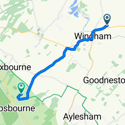
Easy ride in Canterbury
A cycling route starting in Ash, England, United Kingdom.
Overview
About this route
- 22 min
- Duration
- 7.2 km
- Distance
- 36 m
- Ascent
- 32 m
- Descent
- 19.5 km/h
- Avg. speed
- ---
- Avg. speed

Route quality
Waytypes & surfaces along the route
Waytypes
Quiet road
4.1 km
(58 %)
Road
3 km
(41 %)
Surfaces
Paved
1.8 km
(25 %)
Asphalt
1.8 km
(25 %)
Undefined
5.4 km
(75 %)
Continue with Bikemap
Use, edit, or download this cycling route
You would like to ride Easy ride in Canterbury or customize it for your own trip? Here is what you can do with this Bikemap route:
Free features
- Save this route as favorite or in collections
- Copy & plan your own version of this route
- Sync your route with Garmin or Wahoo
Premium features
Free trial for 3 days, or one-time payment. More about Bikemap Premium.
- Navigate this route on iOS & Android
- Export a GPX / KML file of this route
- Create your custom printout (try it for free)
- Download this route for offline navigation
Discover more Premium features.
Get Bikemap PremiumFrom our community
Other popular routes starting in Ash
 Mill Lane, Preston, Canterbury to 22 High St, Canterbury
- Distance
- 14 km
- Ascent
- 65 m
- Descent
- 67 m
- Location
- Ash, England, United Kingdom
 Kent loop 3
- Distance
- 60.8 km
- Ascent
- 258 m
- Descent
- 258 m
- Location
- Ash, England, United Kingdom
 Preston - Stowting
- Distance
- 87 km
- Ascent
- 386 m
- Descent
- 386 m
- Location
- Ash, England, United Kingdom
 Chequer Lane 43, Ash to Chequer Lane 42, Ash
- Distance
- 27.9 km
- Ascent
- 97 m
- Descent
- 100 m
- Location
- Ash, England, United Kingdom
 PluckGutter2Canterbury
- Distance
- 18.8 km
- Ascent
- 70 m
- Descent
- 59 m
- Location
- Ash, England, United Kingdom
 4 Waterworks Cottages, Adisham Road, Canterbury to 4 Waterworks Cottages, Adisham Road, Canterbury
- Distance
- 932.5 km
- Ascent
- 1,057 m
- Descent
- 1,057 m
- Location
- Ash, England, United Kingdom
 Relaxed route in Canterbury
- Distance
- 9.3 km
- Ascent
- 96 m
- Descent
- 44 m
- Location
- Ash, England, United Kingdom
 High Street 73, Wingham to High Street 73, Wingham
- Distance
- 63.1 km
- Ascent
- 776 m
- Descent
- 777 m
- Location
- Ash, England, United Kingdom
Open it in the app