
leichte Bergische Waffel I
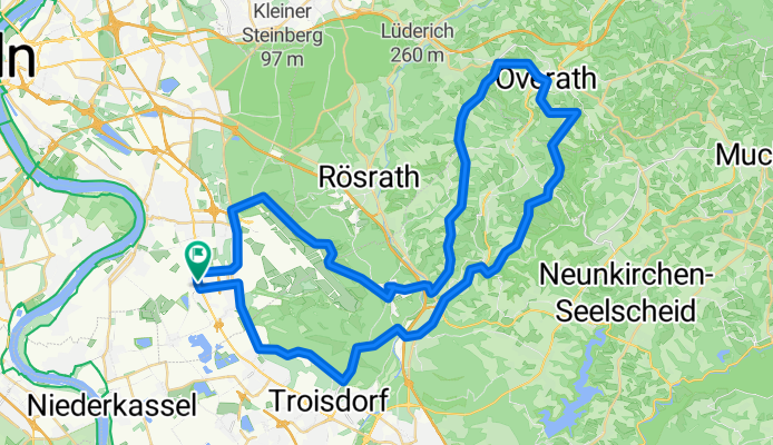
A cycling route starting in Wahn-Heide, North Rhine-Westphalia, Germany.
Overview
About this route
kurz und knapp
- -:--
- Duration
- 57.8 km
- Distance
- 446 m
- Ascent
- 449 m
- Descent
- ---
- Avg. speed
- ---
- Avg. speed
Route quality
Waytypes & surfaces along the route
Waytypes
Busy road
21.7 km
(38 %)
Road
18.3 km
(32 %)
Surfaces
Paved
53.3 km
(92 %)
Unpaved
1.3 km
(2 %)
Asphalt
49.6 km
(86 %)
Paving stones
3.7 km
(6 %)
Continue with Bikemap
Use, edit, or download this cycling route
You would like to ride leichte Bergische Waffel I or customize it for your own trip? Here is what you can do with this Bikemap route:
Free features
- Save this route as favorite or in collections
- Copy & plan your own version of this route
- Sync your route with Garmin or Wahoo
Premium features
Free trial for 3 days, or one-time payment. More about Bikemap Premium.
- Navigate this route on iOS & Android
- Export a GPX / KML file of this route
- Create your custom printout (try it for free)
- Download this route for offline navigation
Discover more Premium features.
Get Bikemap PremiumFrom our community
Other popular routes starting in Wahn-Heide
 Flaches Land zw. Rhein und Sieg
- Distance
- 42.8 km
- Ascent
- 46 m
- Descent
- 47 m
- Location
- Wahn-Heide, North Rhine-Westphalia, Germany
 Spich-Holzlar.gpx
- Distance
- 15.7 km
- Ascent
- 61 m
- Descent
- 24 m
- Location
- Wahn-Heide, North Rhine-Westphalia, Germany
 RTC Köln RTF 2008 150 Km
- Distance
- 141.4 km
- Ascent
- 1,030 m
- Descent
- 1,036 m
- Location
- Wahn-Heide, North Rhine-Westphalia, Germany
 Rath-Heumar,Bensberg,Forsbach
- Distance
- 32 km
- Ascent
- 150 m
- Descent
- 150 m
- Location
- Wahn-Heide, North Rhine-Westphalia, Germany
 KEV Kölnpfad Etappe 10 Stand 201612
- Distance
- 18.9 km
- Ascent
- 63 m
- Descent
- 67 m
- Location
- Wahn-Heide, North Rhine-Westphalia, Germany
 Flughafen Köln/Bonn - Waldbröl
- Distance
- 49.6 km
- Ascent
- 508 m
- Descent
- 236 m
- Location
- Wahn-Heide, North Rhine-Westphalia, Germany
 Um den Flughafen
- Distance
- 33 km
- Ascent
- 160 m
- Descent
- 160 m
- Location
- Wahn-Heide, North Rhine-Westphalia, Germany
 Jakobsweg
- Distance
- 2,145.4 km
- Ascent
- 3,411 m
- Descent
- 3,218 m
- Location
- Wahn-Heide, North Rhine-Westphalia, Germany
Open it in the app