

Mont Joux
A cycling route starting in Saint-Pierre, Aosta Valley, Italy.
Overview
About this route
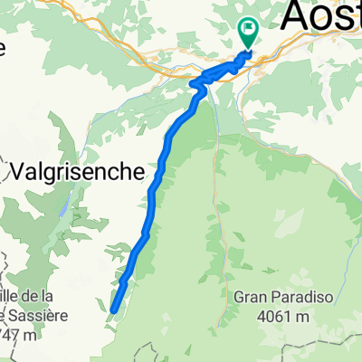
Mont Joux
- -:--
- Duration
- 19 km
- Distance
- 1,264 m
- Ascent
- 0 m
- Descent
- ---
- Avg. speed
- ---
- Avg. speed
Route quality
Waytypes & surfaces along the route
Waytypes
Busy road
8.8 km
(47 %)
Road
7.2 km
(38 %)
Surfaces
Paved
17.7 km
(94 %)
Unpaved
0.7 km
(4 %)
Asphalt
17.7 km
(94 %)
Gravel
0.6 km
(3 %)
Continue with Bikemap
Use, edit, or download this cycling route
You would like to ride Mont Joux or customize it for your own trip? Here is what you can do with this Bikemap route:
Free features
- Save this route as favorite or in collections
- Copy & plan your own version of this route
- Sync your route with Garmin or Wahoo
Premium features
Free trial for 3 days, or one-time payment. More about Bikemap Premium.
- Navigate this route on iOS & Android
- Export a GPX / KML file of this route
- Create your custom printout (try it for free)
- Download this route for offline navigation
Discover more Premium features.
Get Bikemap PremiumFrom our community
Other popular routes starting in Saint-Pierre
 Giro di Vetan
- Distance
- 14.6 km
- Ascent
- 993 m
- Descent
- 29 m
- Location
- Saint-Pierre, Aosta Valley, Italy
 saint pierre Vetan AO
- Distance
- 16 km
- Ascent
- 1,080 m
- Descent
- 24 m
- Location
- Saint-Pierre, Aosta Valley, Italy
 Giro della Valgrisenche
- Distance
- 57.9 km
- Ascent
- 2,007 m
- Descent
- 2,007 m
- Location
- Saint-Pierre, Aosta Valley, Italy
 Vetan da Verrogne
- Distance
- 16.1 km
- Ascent
- 1,131 m
- Descent
- 65 m
- Location
- Saint-Pierre, Aosta Valley, Italy
 vertosan
- Distance
- 32.9 km
- Ascent
- 1,389 m
- Descent
- 196 m
- Location
- Saint-Pierre, Aosta Valley, Italy
 vetan
vetan- Distance
- 16.5 km
- Ascent
- 1,117 m
- Descent
- 10 m
- Location
- Saint-Pierre, Aosta Valley, Italy
 Giro di Vetan
- Distance
- 32.5 km
- Ascent
- 1,126 m
- Descent
- 1,125 m
- Location
- Saint-Pierre, Aosta Valley, Italy
 saint pierre-val di rhemes- saint pierre
- Distance
- 57 km
- Ascent
- 1,422 m
- Descent
- 1,422 m
- Location
- Saint-Pierre, Aosta Valley, Italy
Open it in the app