

Zuckerbahnradweg
A cycling route starting in Tautenhain, Free State of Thuringia, Germany.
Overview
About this route
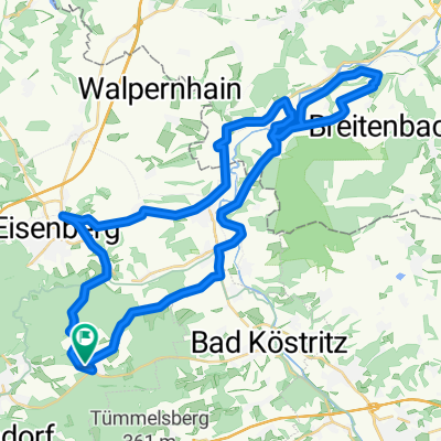
Tautenhain-Zeitz-Zuckerbahnradweg-Schkölen-Eisenberg-Tautenhain
- -:--
- Duration
- 73.5 km
- Distance
- 1,935 m
- Ascent
- 1,935 m
- Descent
- ---
- Avg. speed
- ---
- Avg. speed
Route photos


Route quality
Waytypes & surfaces along the route
Waytypes
Quiet road
22.4 km
(31 %)
Cycleway
18.3 km
(25 %)
Surfaces
Paved
63.4 km
(86 %)
Unpaved
4.4 km
(6 %)
Asphalt
61.3 km
(83 %)
Gravel
2.7 km
(4 %)
Continue with Bikemap
Use, edit, or download this cycling route
You would like to ride Zuckerbahnradweg or customize it for your own trip? Here is what you can do with this Bikemap route:
Free features
- Save this route as favorite or in collections
- Copy & plan your own version of this route
- Sync your route with Garmin or Wahoo
Premium features
Free trial for 3 days, or one-time payment. More about Bikemap Premium.
- Navigate this route on iOS & Android
- Export a GPX / KML file of this route
- Create your custom printout (try it for free)
- Download this route for offline navigation
Discover more Premium features.
Get Bikemap PremiumFrom our community
Other popular routes starting in Tautenhain
 Stetige Fahrt
- Distance
- 6.7 km
- Ascent
- 21 m
- Descent
- 99 m
- Location
- Tautenhain, Free State of Thuringia, Germany
 Bad Köstritz über Lerchenberg und Herrenallee
- Distance
- 23.9 km
- Ascent
- 367 m
- Descent
- 367 m
- Location
- Tautenhain, Free State of Thuringia, Germany
 Elstertalrunde
- Distance
- 48.1 km
- Ascent
- 538 m
- Descent
- 538 m
- Location
- Tautenhain, Free State of Thuringia, Germany
 Tautenburg / Dornburger Schlösser
- Distance
- 71.6 km
- Ascent
- 613 m
- Descent
- 613 m
- Location
- Tautenhain, Free State of Thuringia, Germany
 Tautenhain- Muehltal und zurück
- Distance
- 15.8 km
- Ascent
- 273 m
- Descent
- 273 m
- Location
- Tautenhain, Free State of Thuringia, Germany
 Tautenhain-Muehltal und zurück
- Distance
- 18.7 km
- Ascent
- 283 m
- Descent
- 283 m
- Location
- Tautenhain, Free State of Thuringia, Germany
 Tautenhain, Reichardsdorf, Köstritz,Mühltal, Tautenhain CLONED FROM ROUTE 506560
- Distance
- 27.9 km
- Ascent
- 241 m
- Descent
- 241 m
- Location
- Tautenhain, Free State of Thuringia, Germany
 Alte Bierstraße 3, Tautenhain nach Mühlenstraße 7, Jena
- Distance
- 1,900.1 km
- Ascent
- 268 m
- Descent
- 583 m
- Location
- Tautenhain, Free State of Thuringia, Germany
Open it in the app