
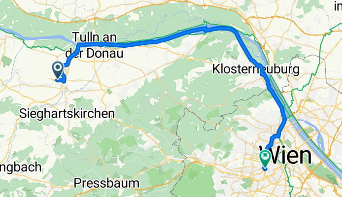
Westbahnhof Wien-Tullnerfeld Bahnhof
A cycling route starting in Langenrohr, Lower Austria, Austria.
Overview
About this route
- -:--
- Duration
- 48 km
- Distance
- 100 m
- Ascent
- 74 m
- Descent
- ---
- Avg. speed
- ---
- Avg. speed

Route quality
Waytypes & surfaces along the route
Waytypes
Cycleway
18.6 km
(39 %)
Track
17.4 km
(36 %)
Surfaces
Paved
46.4 km
(97 %)
Unpaved
0.2 km
(<1 %)
Asphalt
45.7 km
(95 %)
Paved (undefined)
0.6 km
(1 %)
Continue with Bikemap
Use, edit, or download this cycling route
You would like to ride Westbahnhof Wien-Tullnerfeld Bahnhof or customize it for your own trip? Here is what you can do with this Bikemap route:
Free features
- Save this route as favorite or in collections
- Copy & plan your own version of this route
- Sync your route with Garmin or Wahoo
Premium features
Free trial for 3 days, or one-time payment. More about Bikemap Premium.
- Navigate this route on iOS & Android
- Export a GPX / KML file of this route
- Create your custom printout (try it for free)
- Download this route for offline navigation
Discover more Premium features.
Get Bikemap PremiumFrom our community
Other popular routes starting in Langenrohr
 tulln bhf _kamptal _geras _drosendf _hardegg _pulkau __retz plng
- Distance
- 160.4 km
- Ascent
- 716 m
- Descent
- 629 m
- Location
- Langenrohr, Lower Austria, Austria
 Tulln bis Neusiedl
- Distance
- 103.9 km
- Ascent
- 434 m
- Descent
- 493 m
- Location
- Langenrohr, Lower Austria, Austria
 Bahnhofsring 48, Michelhausen nach Am Hafen 4–16, Traismauer
- Distance
- 29.4 km
- Ascent
- 72 m
- Descent
- 63 m
- Location
- Langenrohr, Lower Austria, Austria
 Tulln-Klausen Leopoldsdorf-Laaben Tulln
- Distance
- 104.9 km
- Ascent
- 884 m
- Descent
- 860 m
- Location
- Langenrohr, Lower Austria, Austria
 Langenrohr-Mariazell-Langenrohr
- Distance
- 238.6 km
- Ascent
- 3,312 m
- Descent
- 3,174 m
- Location
- Langenrohr, Lower Austria, Austria
 Z03 Tulln - Krems
- Distance
- 76.7 km
- Ascent
- 228 m
- Descent
- 206 m
- Location
- Langenrohr, Lower Austria, Austria
 Pixendorfer Familyrundweg
- Distance
- 25.6 km
- Ascent
- 33 m
- Descent
- 33 m
- Location
- Langenrohr, Lower Austria, Austria
 L2090 to Hauptallee W, Wien
- Distance
- 48.7 km
- Ascent
- 90 m
- Descent
- 173 m
- Location
- Langenrohr, Lower Austria, Austria
Open it in the app