

Volleyball
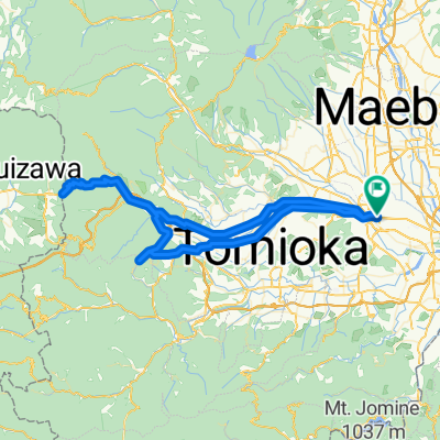
A cycling route starting in Takasaki, Gunma, Japan.
Overview
About this route
- -:--
- Duration
- 12.1 km
- Distance
- 69 m
- Ascent
- 51 m
- Descent
- ---
- Avg. speed
- ---
- Avg. speed

Route quality
Waytypes & surfaces along the route
Waytypes
Quiet road
6.3 km
(52 %)
Road
3.6 km
(30 %)
Surfaces
Paved
0.2 km
(2 %)
Asphalt
0.2 km
(2 %)
Undefined
11.8 km
(98 %)
Continue with Bikemap
Use, edit, or download this cycling route
You would like to ride Volleyball or customize it for your own trip? Here is what you can do with this Bikemap route:
Free features
- Save this route as favorite or in collections
- Copy & plan your own version of this route
- Sync your route with Garmin or Wahoo
Premium features
Free trial for 3 days, or one-time payment. More about Bikemap Premium.
- Navigate this route on iOS & Android
- Export a GPX / KML file of this route
- Create your custom printout (try it for free)
- Download this route for offline navigation
Discover more Premium features.
Get Bikemap PremiumFrom our community
Other popular routes starting in Takasaki
 1142−1 まで甘楽町
- Distance
- 26.1 km
- Ascent
- 431 m
- Descent
- 274 m
- Location
- Takasaki, Gunma, Japan
 2294-30, Yamanamachi, Takasaki to 2294-15, Yamanamachi, Takasaki
- Distance
- 12.1 km
- Ascent
- 95 m
- Descent
- 88 m
- Location
- Takasaki, Gunma, Japan
 222, Yashimacho, Takasaki to 776-1, Kamimogi, Tamamura, Sawa-Gun
- Distance
- 13.3 km
- Ascent
- 35 m
- Descent
- 75 m
- Location
- Takasaki, Gunma, Japan
 35-1, Takamatsucho, Takasaki to 1327, Minaminagano, Nagano
- Distance
- 132.4 km
- Ascent
- 2,395 m
- Descent
- 2,124 m
- Location
- Takasaki, Gunma, Japan
 From Usui-Hill to Takasaki Via Mt.Myogi
- Distance
- 100.9 km
- Ascent
- 1,363 m
- Descent
- 1,361 m
- Location
- Takasaki, Gunma, Japan
 Tour de Japon 7th Stage Takasaki - Nagano
- Distance
- 158.1 km
- Ascent
- 2,188 m
- Descent
- 1,920 m
- Location
- Takasaki, Gunma, Japan
 早瀬川サイクリングロード
- Distance
- 3.4 km
- Ascent
- 20 m
- Descent
- 4 m
- Location
- Takasaki, Gunma, Japan
 Takasaki Sta. to Karuizawa Sta.
- Distance
- 43.8 km
- Ascent
- 908 m
- Descent
- 72 m
- Location
- Takasaki, Gunma, Japan
Open it in the app