

Dayton's D-Day Route June 6-8, 1944
A cycling route starting in Bavent, Normandy, France.
Overview
About this route
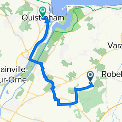
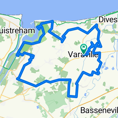
After destroying the bridge over the Dives River, retreat to Robehomme, then through Bavent to Le Mesnil Crossroads, June 7/8 1944. Return to Caen via bike route and back roads June 8, 2019
- -:--
- Duration
- 23.2 km
- Distance
- 137 m
- Ascent
- 131 m
- Descent
- ---
- Avg. speed
- ---
- Avg. speed

Route quality
Waytypes & surfaces along the route
Waytypes
Road
8.4 km
(36 %)
Quiet road
6.9 km
(30 %)
Surfaces
Paved
12.3 km
(53 %)
Asphalt
11.3 km
(49 %)
Concrete
0.8 km
(4 %)
Continue with Bikemap
Use, edit, or download this cycling route
You would like to ride Dayton's D-Day Route June 6-8, 1944 or customize it for your own trip? Here is what you can do with this Bikemap route:
Free features
- Save this route as favorite or in collections
- Copy & plan your own version of this route
- Sync your route with Garmin or Wahoo
Premium features
Free trial for 3 days, or one-time payment. More about Bikemap Premium.
- Navigate this route on iOS & Android
- Export a GPX / KML file of this route
- Create your custom printout (try it for free)
- Download this route for offline navigation
Discover more Premium features.
Get Bikemap PremiumFrom our community
Other popular routes starting in Bavent
 ouistreham
- Distance
- 15.7 km
- Ascent
- 95 m
- Descent
- 117 m
- Location
- Bavent, Normandy, France
 De 1–4 Place du 6 Juin, Petiville à 1–4 Place du 6 Juin, Petiville
- Distance
- 31.8 km
- Ascent
- 64 m
- Descent
- 65 m
- Location
- Bavent, Normandy, France
 Dives River to Robehomme then Caen
- Distance
- 23.3 km
- Ascent
- 144 m
- Descent
- 138 m
- Location
- Bavent, Normandy, France
 2200 Route de Bavent, Goustranville à 18 Rue de la Petite Justice, Bavent
- Distance
- 7.6 km
- Ascent
- 44 m
- Descent
- 20 m
- Location
- Bavent, Normandy, France
 De 3 Rue François Fournier, Bavent à 5 Rue du Faudy, Bavent
- Distance
- 4.1 km
- Ascent
- 30 m
- Descent
- 39 m
- Location
- Bavent, Normandy, France
 De 7 Place de l'Église, Bavent à 1026 Route de Bretagne, Mouen
- Distance
- 27.9 km
- Ascent
- 231 m
- Descent
- 185 m
- Location
- Bavent, Normandy, France
 Marais de Cabourg / Amfreville / Franceville
- Distance
- 51.6 km
- Ascent
- 161 m
- Descent
- 171 m
- Location
- Bavent, Normandy, France
 pégasus Cabourg
- Distance
- 31.6 km
- Ascent
- 94 m
- Descent
- 94 m
- Location
- Bavent, Normandy, France
Open it in the app