

Pragelato - Militare - Setriere - Borgata - Plan - Pragelato
A cycling route starting in Pragelato, Piedmont, Italy.
Overview
About this route
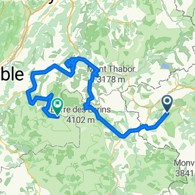
Itinerario sperimentato la scorsa estate per raggiungere la strada militare dell'Assietta. Partendo da Pragelato verso Grand Puy, prendere una deviazione sulla sx, come indicato. Si raggiunge un alpeggio dove è possibile ricaricare la borraccia scambiare due chiacchere con il pastore e volendo aprovvigionarsi di toma. Si prosegue fino alla strada militare seguendo un sentiero. In alcuni punti è molto stretto e si è costretti a scendere di sella. Raggiunta la strada sterrato seguirla verso ovest finoa al Sestriere. Raggiungere Borgata in corrispondenza delle piste da sci ci sono delle strade sterrate. Da borgata a Pattemouche c'e' un sentiero percorribile in mtb. Una volta raggiunta Plan si segue la la pista di fondo olimpica lungo il Chisone fino a Pragelato. Bellissima.
- -:--
- Duration
- 32 km
- Distance
- 1,206 m
- Ascent
- 1,206 m
- Descent
- ---
- Avg. speed
- ---
- Avg. speed
Route highlights
Points of interest along the route
Point of interest after 2.9 km
Deviazione verso alpeggio
Point of interest after 6 km
Alpeggio sopra Gran Puy
Continue with Bikemap
Use, edit, or download this cycling route
You would like to ride Pragelato - Militare - Setriere - Borgata - Plan - Pragelato or customize it for your own trip? Here is what you can do with this Bikemap route:
Free features
- Save this route as favorite or in collections
- Copy & plan your own version of this route
- Sync your route with Garmin or Wahoo
Premium features
Free trial for 3 days, or one-time payment. More about Bikemap Premium.
- Navigate this route on iOS & Android
- Export a GPX / KML file of this route
- Create your custom printout (try it for free)
- Download this route for offline navigation
Discover more Premium features.
Get Bikemap PremiumFrom our community
Other popular routes starting in Pragelato
 Da Strada Provinciale 23 del Colle di Sestriere 5, Pragelato-Ruà a Unnamed Road, Pragelato
- Distance
- 9.6 km
- Ascent
- 428 m
- Descent
- 25 m
- Location
- Pragelato, Piedmont, Italy
 Etapa 4
- Distance
- 11.1 km
- Ascent
- 486 m
- Descent
- 78 m
- Location
- Pragelato, Piedmont, Italy
 Pragelato - Les Deux Alpes-Glacier du Mont Lans
- Distance
- 276.8 km
- Ascent
- 7,733 m
- Descent
- 6,112 m
- Location
- Pragelato, Piedmont, Italy
 Assietta 2
- Distance
- 76.1 km
- Ascent
- 1,960 m
- Descent
- 1,960 m
- Location
- Pragelato, Piedmont, Italy
 Val Troncea
- Distance
- 20.9 km
- Ascent
- 560 m
- Descent
- 598 m
- Location
- Pragelato, Piedmont, Italy
 Pragelato - La Vachette
- Distance
- 78.5 km
- Ascent
- 2,164 m
- Descent
- 2,163 m
- Location
- Pragelato, Piedmont, Italy
 Tour delle Alpi Olimpiche - Olympic Alps Tour
- Distance
- 113.1 km
- Ascent
- 2,343 m
- Descent
- 2,343 m
- Location
- Pragelato, Piedmont, Italy
 Sestriere (e20 Giro)
- Distance
- 10.5 km
- Ascent
- 528 m
- Descent
- 0 m
- Location
- Pragelato, Piedmont, Italy
Open it in the app